
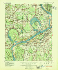
1939 Map of Horseshoe Lake
USGS Topo · Published 1941About this map
Horseshoe Lake and its oxbow neighbors dominate this 1930s landscape along the border of Arkansas and Mississippi, reflecting the restless history of the Mississippi River. The map illustrates a region defined by large-scale agriculture, featuring numerous named estates such as the Abbey Leatherman Plantation, Taylor Lake Belle Meade Plantation, and the Gayoso Lbr Co Plantation. This pattern of settlement, concentrated along the fertile banks and higher ground, is supported by a network of community anchors including the Hopewell Sch & Ch and Morning Star Ch. The presence of the Five Lakes Club and Horseshoe Lake Club suggests the area's development into a recreational destination for nearby Memphis residents during this era. Meanwhile, the Commerce Cut-Off and the Indeterminate State Line trace the complex legal and geographical shifts caused by the river's migration over time.
Find a feature on this map
106 named features on this map. Tap any name to fly to it.
Don’t see what you’re looking for? This feature index may not catch every label — zoom into the map to look around manually.
Map Details
Editions of this 1939 Horseshoe Lake Map
2 editions found
Other maps of this area

1908 · Hollywood
USGS Topo · 1:24,000

1908 · Lake Cormorant
USGS Topo · 1:24,000

1912 · Lake Cormorant
USGS Topo · 1:31,680

1913 · Hollywood
USGS Topo · 1:31,680

1916 · Memphis
USGS Topo · 1:62,500

1925 · Memphis
USGS Topo · 1:48,000

1927 · Memphis
USGS Topo · 1:62,500

1931 · Horseshoe Lake
USGS Topo · 1:62,500

1932 · Horn Lake
USGS Topo · 1:48,000

1932 · Crenshaw
USGS Topo · 1:62,500