1970s Maps of Tipton County, Tennessee
Explore 17 historic maps of Tipton County from the 1970s. These maps offer a rare glimpse into what life looked like during the 1970s — showing old roads, neighborhoods, homes, and landmarks that have changed or disappeared over time.
Whether you're researching your family's past, planning a metal detecting trip, or studying how Tipton County's landscape evolved across the 1970s, these high-resolution maps are a powerful tool for exploring the history of this region.
- Focus on a specific era: All maps on this page are from the 1970s, giving you a focused view of this time period.
- See what’s changed: Compare century-old streets, trails, and buildings to today's modern landscape using overlays and satellite layers.
- Research with precision: Use these maps for genealogy, historical research, land use analysis, or educational projects.
- View, download, or print: Maps are fully viewable online in high resolution, and can be downloaded or printed for your own records.
Start exploring Tipton County's history through authentic maps from the 1970s. This is your window into the past.
Tipton County, TN maps
(17)- 1970 Map of Brownsville
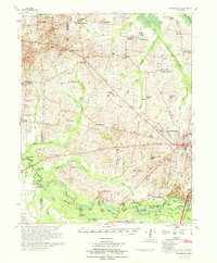 1970 Brownsville1970 Print · USGSHaywood County in the late sixties and early seventies is defined by its deep river bottomlands and scattered rural crossroads. Genealogists and researchers can trace family landmarks and vanished schools like Nutbush, Durhamville, and the Flag Grove Sch.
 - 1970 Map of Drummonds, 1973 Print
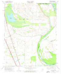
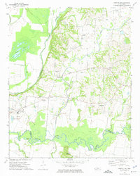
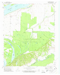
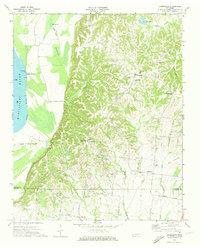 1970 Drummonds1973 Print · USGSTipton County in the early seventies shows a landscape of ridge-top settlements and river bottomlands. Genealogists can locate family landmarks like Poplar Grove Cem, Mt Harmon Jerusalem Ch, and the rural community of Quito.3 unique versions available
 - 1970 Map of Frenchmans Bayou, 1974 Print
 1970 Frenchmans Bayou1974 Print · USGSThe Arkansas-Tennessee borderlands appear here in the early 1970s, defined by the river’s winding chutes and protected agricultural bottoms. Researchers can locate vanished rural landmarks like St Pauls Ch, Shawnee Sch, and the riverside community of Lambethville.2 unique versions available
 - 1970 Map of Pecan Point, 1974 Print
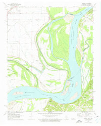
 1970 Pecan Point1974 Print · USGSThe Tennessee-Arkansas borderlands along the Mississippi River are captured here just as modern flood control was maturing. Genealogists and river historians can locate vanished river landings and remote burial sites like Black Cat Landing, Corona, and Jacob Cem.2 unique versions available
 - 1970 Map of Jericho, 1974 Print
 1970 Jericho1974 Print · USGSCrittenden County, Arkansas, and the Mississippi riverfront appear in the 1970s as a managed landscape of agriculture and wildlife preservation. Family historians can trace small-town life in Jericho and Clarkedale, or locate rural markers like Malone Cem and New Mt Zion Ch.2 unique versions available
 - 1970 Map of Locke, 1974 Print
 1970 Locke1974 Print · USGSThe river bluffs of Shelby County are captured here in the early seventies, where state forest lands meet the shifting Mississippi. Researchers can trace rural life and riverside labor through features like Giles Town, Benjestown Cem, and Brandywine Landing.2 unique versions available
 - 1971 Map of Munford, 1973 Print
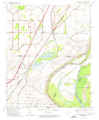
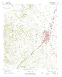
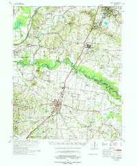
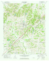 1971 Munford1973 Print · USGSWest Tennessee rural life centers on the rail corridor between Munford and Atoka in the early seventies. Genealogists can trace family roots through numerous local landmarks like Ellis Sch, St Marks Ch, and the Adams Cem.3 unique versions available
 - 1972 Map of Ripley South, 1974 Print
 1972 Ripley South1974 Print · USGSLauderdale County in the early seventies centers on the growing communities of Ripley and Henning along the rail corridor. Genealogists can trace family names at Poplar Grove Cem, Bethlehem Cem, or rural landmarks like Hurricane Hill.2 unique versions available
 - 1972 Map of Fort Pillow, 1974 Print
 1972 Fort Pillow1974 Print · USGSThe bluffs above the Hatchie River and the rural communities of Lauderdale County are frozen in time during the early 1970s. Local researchers can trace old family names and community centers through landmarks like Pilgrim Rest Cem, New Hope Ch, and the Fort Pillow State Farm.
 - 1972 Map of Covington, 1974 Print
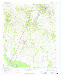
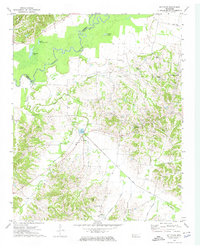
 1972 Covington1974 Print · USGSCovington and rural Tipton County are captured here in the early seventies as the town expanded along the Illinois Central Gulf rail line. Researchers can trace local heritage through the sites of Mount Lebanon, Shiloh Cem, and the Drive-in Theater.2 unique versions available
 - 1972 Map of Gilt Edge, 1974 Print
 1972 Gilt Edge1974 Print · USGSThe rural communities of Tipton and Lauderdale Counties come into focus in the early 1970s, bounded by the winding Hatchie River. Researchers can trace family roots through numerous local landmarks, including Smyrna Cem, Gilt Edge, and Kelley Chapel.2 unique versions available
 - 1972 Map of Gift, 1974 Print
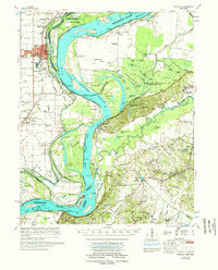
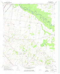 1972 Gift1974 Print · USGSThe Hatchie River floodplain and rural Tipton County are captured here in the early 1970s as agricultural life and aviation growth converged. Researchers can trace family history through numerous landmarks like Tabernacle Sch, Tipton Cem, and churches such as St Luke Ch.2 unique versions available
 - 1972 Map of Golddust, 1975 Print
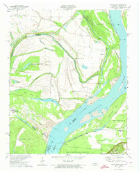
 1972 Golddust1975 Print · USGSThe riverine border between Tennessee and Arkansas is captured here in the early 1970s, documenting a landscape shaped by shifting waters and military history. Genealogists and historians can trace local landmarks like Bethlehem Ch, the Samuels Cem, and the historic breastworks at Fort Pillow.3 unique versions available
 - 1972 Map of Nodena, 1975 Print
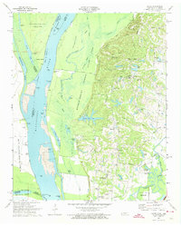
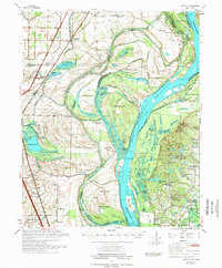
 1972 Nodena1975 Print · USGSThe Mississippi River's shifting path in the 1970s defines this borderland between Tennessee and Arkansas. Trace family roots and vanished landmarks through Old Randolph Cem, the riverside settlement of Nodena, and the strategic Chickasaw Bluff No 1.2 unique versions available
 - 1975 Map of Jericho
 1975 Jericho1975 Print · USGSThe Mississippi River meanders through the Arkansas and Tennessee borderlands in the mid-seventies, documenting a landscape shaped by massive river bars and drainage ditches. Trace family sites at Jericho, Frenchmans Bayou, and small country landmarks like St Paul Cem or Paradise Ch.
 - 1977 Map of Rialto
 1977 Rialto1977 Print · USGSTipton and Lauderdale counties are documented here in the late seventies, showing the traditional river-and-rail corridor along the Hatchie River. Genealogists can trace family landmarks across dozens of sites, including Leighs Chapel, Pilgrims Rest Cem, and the Henning Sch.
 - 1977 Map of Osceola
 1977 Osceola1977 Print · USGSThe Mississippi Delta's winding riverborder comes alive in the 1970s, showing the complex interaction of the Mississippi River and the riverfront communities. Genealogists and local historians can locate many rural landmarks, from Nodena Cem and Mississippi County Memorial Gardens to the river-bluff heights of Fort Pillow State Park.
End of results
Showing maps 1-17 of 17
Top cities of Tipton County
- Covington historical maps
- Atoka historical maps
- Munford historical maps
- Brighton historical maps
- Mason historical maps
- Gilt Edge historical maps
See more
Frequently asked questions
- What are the different types of historical maps available for Tipton County?
- What is the oldest map of Tipton County?
- Where can I purchase historical maps of Tipton County for my home or office?
- Where can I download high-res historical maps of Tipton County?
- Are there historical topographic maps available for Tipton County?
- Is there historical aerial imagery available for Tipton County?
- Where are historical maps of Tipton County sourced from?