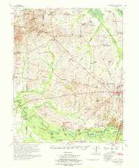
1970 Map of Brownsville
USGS Topo · Published 1970About this map
The Hatchie River bottomlands dominate the southern landscape of this 1970 edition, revealing a complex network of oxbow lakes like Horseshoe Lake and Bond Cutoff Lake. This survey, published by the U.S. Army Corps of Engineers, captures the rural character of Haywood County during a period of steady agricultural tradition. The town of Brownsville serves as the regional hub, connected to the wider world by the Louisville and Nashville Railroad.
Find a feature on this map
98 named features on this map. Tap any name to fly to it.
Don’t see what you’re looking for? This feature index may not catch every label — zoom into the map to look around manually.
Map Details
Editions of this 1970 Brownsville Map
This is the sole edition of this map. No revisions or reprints were ever made.
Other maps of this area

1939 · Hales Point
USGS Topo · 1:62,500

1939 · Halls
USGS Topo · 1:62,500

1950 · Sunnyhill
USGS Topo · 1:24,000

1950 · Brownsville
USGS Topo · 1:24,000

1951 · Brownsville
USGS Topo · 1:24,000

1951 · Sunnyhill
USGS Topo · 1:24,000

1952 · Stanton
USGS Topo · 1:24,000

1952 · Hales Point
USGS Topo · 1:62,500

1952 · Dancyville
USGS Topo · 1:24,000

1952 · Gates
USGS Topo · 1:24,000