1960s Maps of Wilson County, Tennessee
Explore 5 historic maps of Wilson County from the 1960s. These maps offer a rare glimpse into what life looked like during the 1960s — showing old roads, neighborhoods, homes, and landmarks that have changed or disappeared over time.
Whether you're researching your family's past, planning a metal detecting trip, or studying how Wilson County's landscape evolved across the 1960s, these high-resolution maps are a powerful tool for exploring the history of this region.
- Focus on a specific era: All maps on this page are from the 1960s, giving you a focused view of this time period.
- See what’s changed: Compare century-old streets, trails, and buildings to today's modern landscape using overlays and satellite layers.
- Research with precision: Use these maps for genealogy, historical research, land use analysis, or educational projects.
- View, download, or print: Maps are fully viewable online in high resolution, and can be downloaded or printed for your own records.
Start exploring Wilson County's history through authentic maps from the 1960s. This is your window into the past.
Wilson County, TN maps
(5)- 1962 Map of Auburntown, 1963 Print
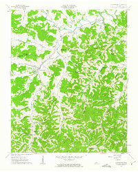 1962 Auburntown1963 Print · USGSThe rural hills of Middle Tennessee in the early 1960s are defined by winding waterways and deep family-named hollows. Genealogists and historians can trace old homesteads and local institutions through landmarks like Auburntown, Cottage Home, and the Odom Cem.4 unique versions available
 - 1962 Map of Milton, 1963 Print
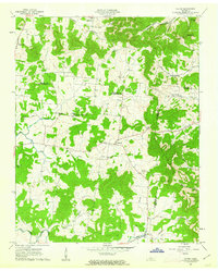 1962 Milton1963 Print · USGSRutherford and Wilson counties met in a landscape of small farms and country churches during the early sixties. Genealogists can trace family footprints through sites like Gloriana Ch, Gaines Cem, and the rural settlements of Milton and Cainsville.3 unique versions available
 - 1968 Map of Hermitage, 1970 Print
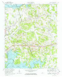 1968 Hermitage1970 Print · USGSThe Hermitage area in the late sixties displays a landscape transitioning from rural estates to suburban reaches between two major Tennessee reservoirs. Trace local history through The Hermitage Tomb, Mount Juliet High Sch, and family-named landmarks like Bakers Grove Ch.3 unique versions available
 - 1968 Map of La Vergne, 1971 Print
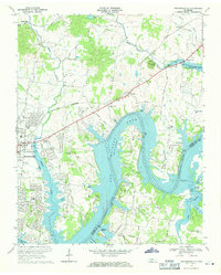
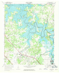 1968 La Vergne1971 Print · USGSIn the late 1960s, the Stones River valley transformed as the J Percy Priest Reservoir rose to its normal pool elevation. Genealogists and local historians can trace the foundations of La Vergne and identify rural landmarks like Burnette Chapel and the Sewart Air Force Base.3 unique versions available
 - 1968 Map of Hendersonville, 1971 Print
 1968 Hendersonville1971 Print · USGSThe Hendersonville area is captured here during its late-sixties growth as Old Hickory Lake reshaped the local topography. Genealogists can trace family roots through landmarks like St Johns Ch, Peytona, and the rural schools and churches of Shackle Island.2 unique versions available
End of results
Showing maps 1-5 of 5
Top cities of Wilson County
Frequently asked questions
- What are the different types of historical maps available for Wilson County?
- What is the oldest map of Wilson County?
- Where can I purchase historical maps of Wilson County for my home or office?
- Where can I download high-res historical maps of Wilson County?
- Are there historical topographic maps available for Wilson County?
- Is there historical aerial imagery available for Wilson County?
- Where are historical maps of Wilson County sourced from?