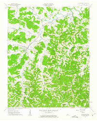
1962 Map of Auburntown
USGS Topo · Published 1963About this map
The Smith Fork river and its many tributaries carve a labyrinth of hollows and ridges across this section of Middle Tennessee, defining the local road and settlement patterns in the early 1960s. Auburntown serves as a primary hub, while smaller communities like Prosperity and Hardscrabble are connected by winding routes like Creek Road. The landscape is densely marked by family-named hollows and landmarks, such as Talent Hollow and the distinctive Fodderstack Knob. Local life is anchored by traditional institutions including the Auburn Sch, Shiloh Ch, and the landmark Cottage Home located near Anderson Hollow. This survey preserves the location of numerous small burial grounds, such as Kennedy Cem and Jones Cem, and natural curiosities like Blowhole Cave, providing a detailed record of the rural landscape before modern development altered these small agricultural valleys.
Find a feature on this map
59 named features on this map. Tap any name to fly to it.
Don’t see what you’re looking for? This feature index may not catch every label — zoom into the map to look around manually.
Map Details
Editions of this 1962 Auburntown Map
4 editions found
Other maps of this area

1893 · Mc Minnville
USGS Topo · 1:125,000

1895 · Mc Minnville
USGS Topo · 1:125,000

1908 · Woodbury
USGS Topo · 1:62,500

1928 · Gordonsville
USGS Topo · 1:62,500

1942 · Statesville
USGS Topo · 1:100,000

1953 · Chattanooga
USGS Topo · 1:250,000

1956 · Columbia
USGS Topo · 1:250,000

1956 · Corbin
USGS Topo · 1:250,000

1956 · Nashville
USGS Topo · 1:250,000

1957 · Chattanooga
USGS Topo · 1:250,000