1990s Maps of Wilson County, Tennessee
Explore 9 historic maps of Wilson County from the 1990s. These maps offer a rare glimpse into what life looked like during the 1990s — showing old roads, neighborhoods, homes, and landmarks that have changed or disappeared over time.
Whether you're researching your family's past, planning a metal detecting trip, or studying how Wilson County's landscape evolved across the 1990s, these high-resolution maps are a powerful tool for exploring the history of this region.
- Focus on a specific era: All maps on this page are from the 1990s, giving you a focused view of this time period.
- See what’s changed: Compare century-old streets, trails, and buildings to today's modern landscape using overlays and satellite layers.
- Research with precision: Use these maps for genealogy, historical research, land use analysis, or educational projects.
- View, download, or print: Maps are fully viewable online in high resolution, and can be downloaded or printed for your own records.
Start exploring Wilson County's history through authentic maps from the 1990s. This is your window into the past.
Wilson County, TN maps
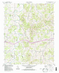
(9)- 1994 Map of Watertown, 1997 Print
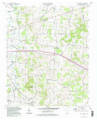
 1994 Watertown1997 Print · USGSWilson County's rural landscape is captured here in the mid-nineties, showing a network of ridge-and-hollow settlements. Researchers can trace family history through sites like Doaks Crossroads, Norene Sch, and the Smith Fork Cem Ch.
 - 1994 Map of Bellwood, 1997 Print
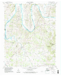 1994 Bellwood1997 Print · USGSThe river bends and rural uplands of the Wilson and Trousdale county lines are shown here during the late twentieth century. Researchers can trace family sites from Centerville to Taylorsville, alongside landmarks like Dickerson Chapel and Tomlinson Cem.
 - 1994 Map of Shop Springs, 1997 Print
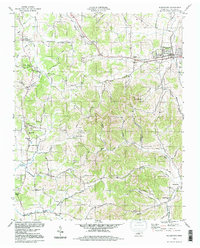
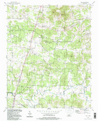
 1994 Shop Springs1997 Print · USGSWilson County in the mid-nineties remained a landscape of quiet crossroads and historic congregation sites. Genealogists and local researchers can trace family landmarks like Linwood Cem, Shop Springs, and numerous churches from Grissim Ch to Bethlehem Ch.
 - 1994 Map of Dixon Springs, 1997 Print
 1994 Dixon Springs1997 Print · USGSThe Cumberland River bends through Smith County in the 1990s, where reservoir waters have reshaped the valley floor. Genealogists can locate family landmarks like Piper-Hughes Cem, Chapel Hill Ch, and the rural settlement of Dixon Springs.
 - 1994 Map of New Middleton, 1997 Print
 1994 New Middleton1997 Print · USGSThe Tennessee interior during the mid-1990s reveals a quiet landscape of agricultural valleys and family-named knobs along the Wilson Co Smith Co line. Local history enthusiasts can trace the rural communities of New Middleton and Grant alongside landmarks like Rawls Creek Ch and Bethlehem Cem.
 - 1994 Map of Hunters Point, 1997 Print
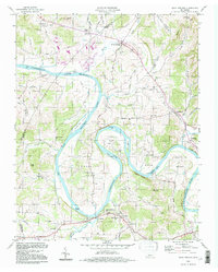
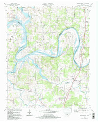 1994 Hunters Point1997 Print · USGSThe Cumberland River loops through Wilson and Sumner counties in the mid-1990s, where old oxbows meet the modern waters of Old Hickory Lake. Researchers can trace early settlements at Cairo and Macedonia, or locate rural landmarks like Carroll Sch and the Nathan J Harsh Bridge.
 - 1994 Map of Vine, 1997 Print
 1994 Vine1997 Print · USGSThe Wilson and Rutherford county borderlands appear in the mid-nineties as a landscape of dense state forests and scattered rural hamlets. Researchers can trace family landmarks like Jacobs Hill Ch, find the old crossing at Bairds Mill, or explore Hermit Cave.
 - 1997 Map of Hermitage, 2001 Print
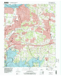 1997 Hermitage2001 Print · USGSThe suburbs east of Nashville were rapidly evolving in the late nineties as legacy estates met modern reservoirs. Genealogists and historians can trace the grounds of The Hermitage, locate the Mount Juliet Cem, and explore the shoreline of Old Hickory Lake.
 - 1997 Map of La Vergne, 2002 Print
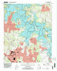 1997 La Vergne2002 Print · USGSThe Rutherford and Davidson County line near La Vergne underwent significant change in the late twentieth century as the Stones River valley was transformed by a massive reservoir. Researchers can trace the footprint of older communities like Couchville and Savage alongside more modern developments like the Smyrna Airport and Hamilton Creek Park.
End of results
Showing maps 1-9 of 9
Top cities of Wilson County
Frequently asked questions
- What are the different types of historical maps available for Wilson County?
- What is the oldest map of Wilson County?
- Where can I purchase historical maps of Wilson County for my home or office?
- Where can I download high-res historical maps of Wilson County?
- Are there historical topographic maps available for Wilson County?
- Is there historical aerial imagery available for Wilson County?
- Where are historical maps of Wilson County sourced from?