1950s Maps of Rockport, Texas
Explore 8 historic maps of Rockport from the 1950s. These maps offer a rare glimpse into what life looked like during the 1950s — showing old roads, neighborhoods, homes, and landmarks that have changed or disappeared over time.
Whether you're researching your family's past, planning a metal detecting trip, or studying how Rockport's landscape evolved across the 1950s, these high-resolution maps are a powerful tool for exploring the history of this region.
- Focus on a specific era: All maps on this page are from the 1950s, giving you a focused view of this time period.
- See what’s changed: Compare century-old streets, trails, and buildings to today's modern landscape using overlays and satellite layers.
- Research with precision: Use these maps for genealogy, historical research, land use analysis, or educational projects.
- View, download, or print: Maps are fully viewable online in high resolution, and can be downloaded or printed for your own records.
Start exploring Rockport's history through authentic maps from the 1950s. This is your window into the past.
Rockport, TX maps
(8)- 1950 Map of Corpus Christi, 1953 Print
 1950 Corpus Christi1953 Print · USGSThe South Texas coast comes into focus during the early fifties, showing the interplay between booming oil fields and expansive ranching operations. Genealogists and historians can trace the Texas Mexican rail line through Kingsville or locate heritage sites like Chapman Ranch and Riviera Beach.
 - 1952 Map of St. Charles Bay SW, 1953 Print
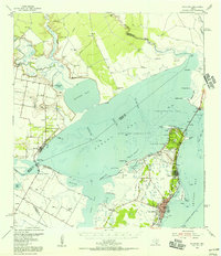
 1952 St. Charles Bay SW1953 Print · USGSThe Aransas coast in the early 1950s reveals a wild landscape of shifting shoals and new energy infrastructure. You can trace the path of the Intracoastal Waterway past Deadman Island and the sprawling Mud Flats of Joseph Island.3 unique versions available
 - 1953 Map of Beeville
 1953 Beeville1953 Print · USGSThe Texas Coastal Bend in the early fifties shows a landscape of growing regional hubs and vital maritime corridors. Trace the rail-and-river economy through Goliad, locate the Matagorda Lighthouse, and explore the sprawling Aransas National Wildlife Refuge.
 - 1954 Map of Rockport, 1956 Print
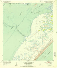
 1954 Rockport1956 Print · USGSThe Aransas County coast comes to life in the mid-fifties, showing the growth of Rockport and the expansion of the Fulton Beach Oil Field. Researchers can locate family landmarks like Mc Lester Cem and trace the early layout of the Aransas County Airport.2 unique versions available
 - 1954 Map of Estes, 1956 Print
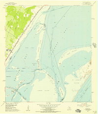 1954 Estes1956 Print · USGSThe Aransas coast in the mid-fifties reveals a landscape of barrier islands and early industrial sites like the Carbon Black Plant. Trace historical rail lines through Estes or locate the San Antonio Cem and the Old Terminal.
 - 1954 Map of Aransas Pass, 1964 Print
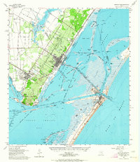 1954 Aransas Pass1964 Print · USGSThe Texas Gulf Coast comes alive in the mid-fifties, showing the growth of Aransas Pass and Port Aransas alongside vital rail and shipping corridors. Trace old routes like the Toll Road on Mustang Island and locate sites such as Prairie View Cem or the Coast Guard Station.2 unique versions available
 - 1956 Map of Corpus Christi
 1956 Corpus Christi1956 Print · USGSThe South Texas coast and the burgeoning port of Corpus Christi are captured here during the mid-fifties. Genealogists and historians can trace the rail-and-oil economy through labels like Robstown Airpark, Chapman Ranch, and the Missouri Pacific railroad.
 - 1956 Map of Beeville
 1956 Beeville1956 Print · USGSCoastal Texas and the brush country interior are shown in the mid-fifties, from the coastal bays to the inland oil fields. Trace the old rail lines of the Southern Pacific RR or locate the historic Matagorda Lighthouse and the Aransas National Wildlife Refuge.2 unique versions available
End of results
Showing maps 1-8 of 8
Top cities near Rockport
- Corpus Christi historical maps
- Ingleside historical maps
- Aransas Pass historical maps
- Port Aransas historical maps
- Gregory historical maps
- Fulton historical maps
See more
Top neighborhoods of Rockport
Frequently asked questions
- What are the different types of historical maps available for Rockport?
- What is the oldest map of Rockport?
- Where can I purchase historical maps of Rockport for my home or office?
- Where can I download high-res historical maps of Rockport?
- Are there historical topographic maps available for Rockport?
- Is there historical aerial imagery available for Rockport?
- Where are historical maps of Rockport sourced from?