Old Maps of Rockport, Texas for Hiking & Exploration
Hike through history with 35 historic maps of Rockport. Explore old trails, ghost towns, and forgotten backroads — perfect for outdoor adventurers and local explorers.
- Rediscover forgotten places: Map out old mining camps, roads, and footpaths that no longer exist on modern maps.
- Layer with modern tools: Combine with LiDAR or satellite views to plan hikes through historical terrain.
- Made for exploration: Popular among hikers, overlanders, and local history lovers.
Use these maps to find adventure and explore the hidden past of Rockport.
Rockport, TX maps
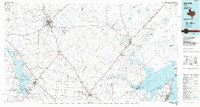
(35)- 1925 Map of Aransas Pass
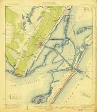 1925 Aransas Pass1925 Print · USGSThe Texas Gulf Coast comes to life in the mid-1920s, showing the early railroad developments and barrier island geography of the coastal bend. Trace the original footprints of Aransas Pass, the Aransas Pass Lighthouse, and local landmarks like Mc Campbell School.3 unique versions available
 - 1950 Map of Corpus Christi, 1953 Print
 1950 Corpus Christi1953 Print · USGSThe South Texas coast comes into focus during the early fifties, showing the interplay between booming oil fields and expansive ranching operations. Genealogists and historians can trace the Texas Mexican rail line through Kingsville or locate heritage sites like Chapman Ranch and Riviera Beach.
 - 1952 Map of St. Charles Bay SW, 1953 Print
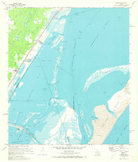
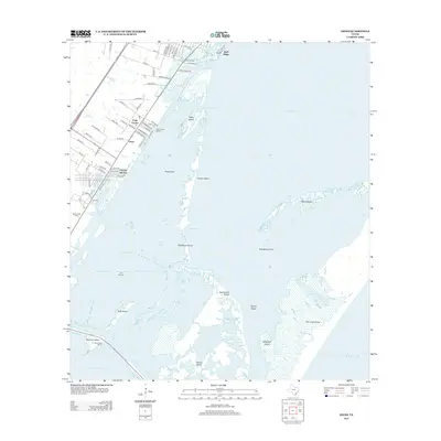
 1952 St. Charles Bay SW1953 Print · USGSThe Aransas coast in the early 1950s reveals a wild landscape of shifting shoals and new energy infrastructure. You can trace the path of the Intracoastal Waterway past Deadman Island and the sprawling Mud Flats of Joseph Island.3 unique versions available
 - 1953 Map of Beeville
 1953 Beeville1953 Print · USGSThe Texas Coastal Bend in the early fifties shows a landscape of growing regional hubs and vital maritime corridors. Trace the rail-and-river economy through Goliad, locate the Matagorda Lighthouse, and explore the sprawling Aransas National Wildlife Refuge.
 - 1954 Map of Rockport, 1956 Print
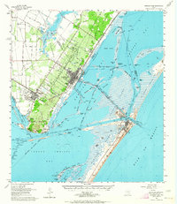
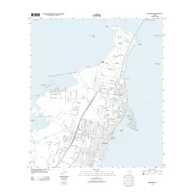
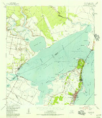 1954 Rockport1956 Print · USGSThe Aransas County coast comes to life in the mid-fifties, showing the growth of Rockport and the expansion of the Fulton Beach Oil Field. Researchers can locate family landmarks like Mc Lester Cem and trace the early layout of the Aransas County Airport.2 unique versions available
 - 1954 Map of Estes, 1956 Print
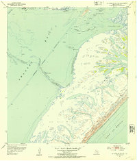
 1954 Estes1956 Print · USGSThe Aransas coast in the mid-fifties reveals a landscape of barrier islands and early industrial sites like the Carbon Black Plant. Trace historical rail lines through Estes or locate the San Antonio Cem and the Old Terminal.
 - 1954 Map of Aransas Pass, 1964 Print
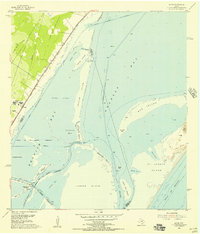
 1954 Aransas Pass1964 Print · USGSThe Texas Gulf Coast comes alive in the mid-fifties, showing the growth of Aransas Pass and Port Aransas alongside vital rail and shipping corridors. Trace old routes like the Toll Road on Mustang Island and locate sites such as Prairie View Cem or the Coast Guard Station.2 unique versions available
 - 1956 Map of Corpus Christi
 1956 Corpus Christi1956 Print · USGSThe South Texas coast and the burgeoning port of Corpus Christi are captured here during the mid-fifties. Genealogists and historians can trace the rail-and-oil economy through labels like Robstown Airpark, Chapman Ranch, and the Missouri Pacific railroad.
 - 1956 Map of Beeville
 1956 Beeville1956 Print · USGSCoastal Texas and the brush country interior are shown in the mid-fifties, from the coastal bays to the inland oil fields. Trace the old rail lines of the Southern Pacific RR or locate the historic Matagorda Lighthouse and the Aransas National Wildlife Refuge.2 unique versions available
 - 1960 Map of Beeville
 1960 Beeville1960 Print · USGSCoastal Texas in the mid-fifties reveals a landscape of growing towns and vital military outposts like Foster AFB. Researchers can trace old rail lines including the Missouri Pacific and explore the vast Aransas National Wildlife Refuge.
 - 1960 Map of Corpus Christi
 1960 Corpus Christi1960 Print · USGSCoastal South Texas and the Nueces County hinterlands are detailed in this mid-century survey. Genealogists and historians can trace early settlement patterns and rural landmarks like Casa Blanca during a period of steady regional growth.
 - 1966 Map of Corpus Christi
 1966 Corpus Christi1966 Print · USGSThe Texas Coastal Bend in the mid-1960s reveals a landscape where massive cattle empires and strategic military bases meet the Gulf. Trace the vast reaches of King Ranch or locate aviation history at the Corpus Christi Air Station and Kingsville Air Station.
 - 1971 Map of Estes, 1973 Print
 1971 Estes1973 Print · USGSCoastal Texas in the early seventies reveals a landscape of industrial infrastructure and emerging shorefront communities along the Aransas County line. Trace the rail-and-water economy at the Carbon Black Plant or locate local landmarks like San Antonio Cem and City-by-the-Sea.3 unique versions available
 - 1979 Map of Rockport
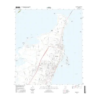
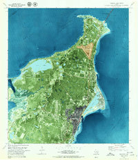 1979 Rockport1979 Print · USGSThe Aransas County coast comes alive in the late seventies as local development reshapes the Live Oak Peninsula. Trace the residential growth of Rockport and Fulton, the canal systems of Key Allegro, and burials at Mc Lester Cem.3 unique versions available
 - 1983 Map of San Antonio Bay
 1983 San Antonio Bay1983 Print · USGSThe Texas Coastal Bend in the early eighties is a landscape of expansive estuaries and barrier islands. Local historians can trace the development of Port O'Connor and Seadrift, the boundaries of the Aransas National Wildlife Refuge, and the path of an Old RR Grade near Tivoli.
 - 1984 Map of Corpus Christi
 1984 Corpus Christi1984 Print · USGSThe Texas Coastal Bend in the 1980s reveals a landscape defined by deep-water ports and sprawling ranchlands. Researchers can trace the rail lines of the Texas Mexican railroad or locate historical landmarks like the Chapman Ranch and Seaside Memorial Cem.
 - 1985 Map of Beeville
 1985 Beeville1985 Print · USGSCoastal South Texas is captured here in the mid-1980s, from the inland plains of Beeville to the estuaries of the Gulf. Genealogists and researchers can trace local landmarks like Chase Field Naval Air Station or follow the historic Southern Pacific rail lines through Skidmore and Woodsboro.2 unique versions available
 - 1989 Map of Corpus Christi, 1991 Print
 1989 Corpus Christi1991 Print · USGSCoastal South Texas and its deep bays are captured here in the late eighties, showcasing a landscape of military aviation and barrier island preservation. Researchers can trace family roots in Petronila or Vattmannville and locate landmarks like Cabaniss Field and Baffin.
 - 2010 Map of Rockport, 2010 Print
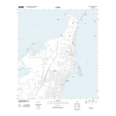 2010 Rockport2010 Print · USGSCovers Rockport, including Fulton, Copano Village, and other nearby areas
 - 2010 Map of Saint Charles Bay SW, 2010 Print
 2010 Saint Charles Bay SW2010 Print · USGSCovers Rockport, including Aransas County, United States, and other nearby areas
 - 2010 Map of Estes, 2010 Print
 2010 Estes2010 Print · USGSCovers Rockport, including Corpus Christi, Aransas Pass, and other nearby areas
 - 2013 Map of Saint Charles Bay SW, 2013 Print
 2013 Saint Charles Bay SW2013 Print · USGSCovers Rockport, including Aransas County, United States, and other nearby areas
 - 2013 Map of Estes, 2013 Print
 2013 Estes2013 Print · USGSCovers Rockport, including Corpus Christi, Aransas Pass, and other nearby areas
 - 2013 Map of Rockport, 2013 Print
 2013 Rockport2013 Print · USGSCovers Rockport, including Fulton, Copano Village, and other nearby areas
 - 2016 Map of Rockport, 2016 Print
 2016 Rockport2016 Print · USGSCovers Rockport, including Fulton, Copano Village, and other nearby areas
Showing maps 1-25 of 35
Top cities near Rockport
- Corpus Christi historical maps
- Ingleside historical maps
- Aransas Pass historical maps
- Port Aransas historical maps
- Gregory historical maps
- Fulton historical maps
See more
Top neighborhoods of Rockport
Frequently asked questions
- What are the different types of historical maps available for Rockport?
- What is the oldest map of Rockport?
- Where can I purchase historical maps of Rockport for my home or office?
- Where can I download high-res historical maps of Rockport?
- Are there historical topographic maps available for Rockport?
- Is there historical aerial imagery available for Rockport?
- Where are historical maps of Rockport sourced from?