1920s Maps of Temple, Texas
Explore 4 historic maps of Temple from the 1920s. These maps offer a rare glimpse into what life looked like during the 1920s — showing old roads, neighborhoods, homes, and landmarks that have changed or disappeared over time.
Whether you're researching your family's past, planning a metal detecting trip, or studying how Temple's landscape evolved across the 1920s, these high-resolution maps are a powerful tool for exploring the history of this region.
- Focus on a specific era: All maps on this page are from the 1920s, giving you a focused view of this time period.
- See what’s changed: Compare century-old streets, trails, and buildings to today's modern landscape using overlays and satellite layers.
- Research with precision: Use these maps for genealogy, historical research, land use analysis, or educational projects.
- View, download, or print: Maps are fully viewable online in high resolution, and can be downloaded or printed for your own records.
Start exploring Temple's history through authentic maps from the 1920s. This is your window into the past.
Temple, TX maps
(4)- 1924 Map of Gatesville 4-d
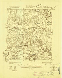 1924 Gatesville 4-d1924 Print · USGSBell County in the mid-twenties shows a landscape of river-valley homesteads and remote rail sidings along the Leon River. Genealogists can locate several rural community landmarks, including Wiltonville School, Youngsport, and Beren Crossing.
 - 1924 Map of Gatesville 4-a
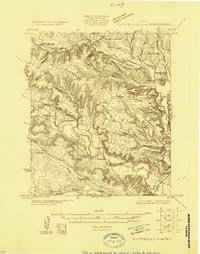 1924 Gatesville 4-a1924 Print · USGSBell and Coryell Counties are mapped here in the mid-1920s, revealing a landscape of upland farms and valley crossings. Genealogists can trace early landmarks like Seattle, Sparta, and Liberty Hill Church, along with rural schoolhouses such as Phoenix School.
 - 1924 Map of Temple 3-C
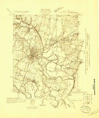 1924 Temple 3-C1924 Print · USGSBell County at the peak of the rail era shows a landscape where river valleys were the centers of life. Genealogists can locate family landmarks like Rock School, Midway Church, and the winding Meridian Highway.
 - 1924 Map of Temple 3-B
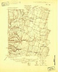 1924 Temple 3-B1924 Print · USGSBell County agriculture and rural life are captured in the mid-1920s as small communities thrived along the Leon River. Genealogists can trace early homesteads near the Whitehall School, Moffat, and the Hopewell Church.
End of results
Showing maps 1-4 of 4
Top cities near Temple
- Harker Heights historical maps
- Belton historical maps
- Nolanville historical maps
- Troy historical maps
- Salado historical maps
- Little River-Academy historical maps
See more
Top neighborhoods of Temple
- Gober historical maps
- Belco historical maps
- Midway historical maps
- Smith historical maps
- Woodland historical maps
- Berger historical maps
See more
Frequently asked questions
- What are the different types of historical maps available for Temple?
- What is the oldest map of Temple?
- Where can I purchase historical maps of Temple for my home or office?
- Where can I download high-res historical maps of Temple?
- Are there historical topographic maps available for Temple?
- Is there historical aerial imagery available for Temple?
- Where are historical maps of Temple sourced from?