1930s Maps of Temple, Texas
Explore 2 historic maps of Temple from the 1930s. These maps offer a rare glimpse into what life looked like during the 1930s — showing old roads, neighborhoods, homes, and landmarks that have changed or disappeared over time.
Whether you're researching your family's past, planning a metal detecting trip, or studying how Temple's landscape evolved across the 1930s, these high-resolution maps are a powerful tool for exploring the history of this region.
- Focus on a specific era: All maps on this page are from the 1930s, giving you a focused view of this time period.
- See what’s changed: Compare century-old streets, trails, and buildings to today's modern landscape using overlays and satellite layers.
- Research with precision: Use these maps for genealogy, historical research, land use analysis, or educational projects.
- View, download, or print: Maps are fully viewable online in high resolution, and can be downloaded or printed for your own records.
Start exploring Temple's history through authentic maps from the 1930s. This is your window into the past.
Temple, TX maps
(2)- 1930 Map of Killeen
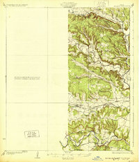 1930 Killeen1930 Print · USGSBell County was a landscape of small school districts and river crossings in the early thirties. Genealogists can trace family roots through rural landmarks like Keyes Valley Sch, Youngsport, and the Santa Fe line at Stone Siding.2 unique versions available
 - 1931 Map of Belton, 1949 Print
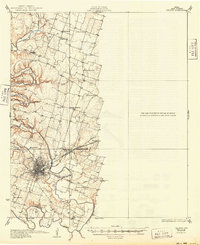 1931 Belton1949 Print · USGSBell County in the 1920s and 30s reveals a landscape of river-valley farming and bustling railroad junctions centered on the county seat. Genealogists and historians can trace early community life through numerous rural landmarks like Moffat Sch, Tennessee Valley Ch, and the Belton and Temple Electric R R.
End of results
Showing maps 1-2 of 2
Top cities near Temple
- Harker Heights historical maps
- Belton historical maps
- Nolanville historical maps
- Troy historical maps
- Salado historical maps
- Little River-Academy historical maps
See more
Top neighborhoods of Temple
- Gober historical maps
- Belco historical maps
- Midway historical maps
- Smith historical maps
- Woodland historical maps
- Berger historical maps
See more
Frequently asked questions
- What are the different types of historical maps available for Temple?
- What is the oldest map of Temple?
- Where can I purchase historical maps of Temple for my home or office?
- Where can I download high-res historical maps of Temple?
- Are there historical topographic maps available for Temple?
- Is there historical aerial imagery available for Temple?
- Where are historical maps of Temple sourced from?