1990s Maps of Temple, Texas
Explore 2 historic maps of Temple from the 1990s. These maps offer a rare glimpse into what life looked like during the 1990s — showing old roads, neighborhoods, homes, and landmarks that have changed or disappeared over time.
Whether you're researching your family's past, planning a metal detecting trip, or studying how Temple's landscape evolved across the 1990s, these high-resolution maps are a powerful tool for exploring the history of this region.
- Focus on a specific era: All maps on this page are from the 1990s, giving you a focused view of this time period.
- See what’s changed: Compare century-old streets, trails, and buildings to today's modern landscape using overlays and satellite layers.
- Research with precision: Use these maps for genealogy, historical research, land use analysis, or educational projects.
- View, download, or print: Maps are fully viewable online in high resolution, and can be downloaded or printed for your own records.
Start exploring Temple's history through authentic maps from the 1990s. This is your window into the past.
Temple, TX maps
(2)- 1995 Map of Nolanville
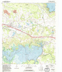 1995 Nolanville1995 Print · USGSBell County was a landscape of military boundaries and major reservoirs during the mid-nineties. You can trace family roots at McDowell Cem, locate Sparta, and see the early footprint of Nolanville before its recent expansion.
 - 1995 Map of Bland
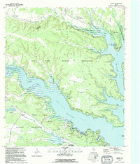 1995 Bland1995 Print · USGSThe Bell and Coryell county line in the mid-1990s shows the convergence of military training and lakefront recreation. Genealogists and locals can trace rural landmarks like Union Hill and Liberty Hill alongside the Fort Hood Military Reservation.
End of results
Showing maps 1-2 of 2
Top cities near Temple
- Harker Heights historical maps
- Belton historical maps
- Nolanville historical maps
- Troy historical maps
- Salado historical maps
- Little River-Academy historical maps
See more
Top neighborhoods of Temple
- Gober historical maps
- Belco historical maps
- Midway historical maps
- Smith historical maps
- Woodland historical maps
- Berger historical maps
See more
Frequently asked questions
- What are the different types of historical maps available for Temple?
- What is the oldest map of Temple?
- Where can I purchase historical maps of Temple for my home or office?
- Where can I download high-res historical maps of Temple?
- Are there historical topographic maps available for Temple?
- Is there historical aerial imagery available for Temple?
- Where are historical maps of Temple sourced from?