1940s Maps of Temple, Texas
Explore 3 historic maps of Temple from the 1940s. These maps offer a rare glimpse into what life looked like during the 1940s — showing old roads, neighborhoods, homes, and landmarks that have changed or disappeared over time.
Whether you're researching your family's past, planning a metal detecting trip, or studying how Temple's landscape evolved across the 1940s, these high-resolution maps are a powerful tool for exploring the history of this region.
- Focus on a specific era: All maps on this page are from the 1940s, giving you a focused view of this time period.
- See what’s changed: Compare century-old streets, trails, and buildings to today's modern landscape using overlays and satellite layers.
- Research with precision: Use these maps for genealogy, historical research, land use analysis, or educational projects.
- View, download, or print: Maps are fully viewable online in high resolution, and can be downloaded or printed for your own records.
Start exploring Temple's history through authentic maps from the 1940s. This is your window into the past.
Temple, TX maps
(3)- 1947 Map of Bland, 1953 Print
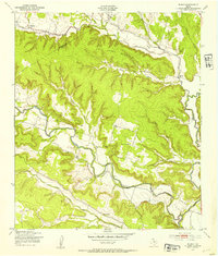 1947 Bland1953 Print · USGSBell and Coryell County rural life is captured here in the late 1940s, documenting a landscape of small schools and family cemeteries. Trace the heritage of Sparta and Bland or locate ancestral sites like Liberty Hill Cem and Phoenix Sch.
 - 1947 Map of Killeen, 1953 Print
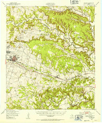 1947 Killeen1953 Print · USGSBell and Coryell Counties appear here in the years following the war, showcasing the early growth of Killeen and the Fort Hood Military Reservation. Local historians can trace vanished schoolhouses and churches like Union Hill Sch and McDowell Ch alongside the Gulf Colorado and Santa Fe line.
 - 1947 Map of Nolanville, 1953 Print
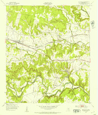 1947 Nolanville1953 Print · USGSNolanville and the surrounding Bell County ranchlands are captured here in the late 1940s as the rail and river networks shaped the local economy. Researchers can trace rural landmarks including Union Grove Sch, Burris Cem, and the path of the Gulf Colorado and Santa Fe railroad.
End of results
Showing maps 1-3 of 3
Top cities near Temple
- Harker Heights historical maps
- Belton historical maps
- Nolanville historical maps
- Troy historical maps
- Salado historical maps
- Little River-Academy historical maps
See more
Top neighborhoods of Temple
- Gober historical maps
- Belco historical maps
- Midway historical maps
- Smith historical maps
- Woodland historical maps
- Berger historical maps
See more
Frequently asked questions
- What are the different types of historical maps available for Temple?
- What is the oldest map of Temple?
- Where can I purchase historical maps of Temple for my home or office?
- Where can I download high-res historical maps of Temple?
- Are there historical topographic maps available for Temple?
- Is there historical aerial imagery available for Temple?
- Where are historical maps of Temple sourced from?