1930s Maps of Brazoria County, Texas
Explore 6 historic maps of Brazoria County from the 1930s. These maps offer a rare glimpse into what life looked like during the 1930s — showing old roads, neighborhoods, homes, and landmarks that have changed or disappeared over time.
Whether you're researching your family's past, planning a metal detecting trip, or studying how Brazoria County's landscape evolved across the 1930s, these high-resolution maps are a powerful tool for exploring the history of this region.
- Focus on a specific era: All maps on this page are from the 1930s, giving you a focused view of this time period.
- See what’s changed: Compare century-old streets, trails, and buildings to today's modern landscape using overlays and satellite layers.
- Research with precision: Use these maps for genealogy, historical research, land use analysis, or educational projects.
- View, download, or print: Maps are fully viewable online in high resolution, and can be downloaded or printed for your own records.
Start exploring Brazoria County's history through authentic maps from the 1930s. This is your window into the past.
Brazoria County, TX maps
(6)- 1932 Map of Algoa
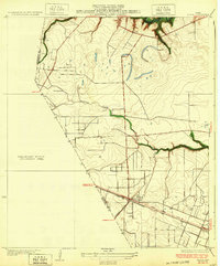 1932 Algoa1932 Print · USGSCoastal Texas in the early thirties centers on the railroad junction at Algoa, where steam-era transportation met the early automotive age. Genealogists and historians can trace the crossing of the Missouri Pacific and Gulf Colorado and Santa Fe near Dickinson Bayou.3 unique versions available
 - 1932 Map of Genoa
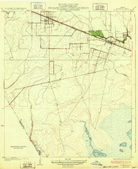
 1932 Genoa1932 Print · USGSSoutheast Texas coastal prairie life in the early thirties is defined by emerging aviation and rail corridors. Genealogists can trace family footprints near Genoa or find the early layout of Olcott (Ellington Field) and the Friendswood Bridge.3 unique versions available
 - 1932 Map of Hitchcock
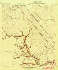
 1932 Hitchcock1932 Print · USGSThe coastal prairies of Galveston County come into focus during the early thirties as rail and ranching shaped the landscape. Genealogists and local researchers can trace early settlements at Hitchcock and Alta Loma, or locate the Galveston Memorial Cemetery near the banks of Highland Bayou.2 unique versions available
 - 1932 Map of Mustang Bayou
 1932 Mustang Bayou1932 Print · USGSThe coastal prairie of the upper Gulf Coast is captured here in the early thirties as local officials began formalizing land boundaries. Genealogists and historians can trace the early layout of Arcadia and the boundary between Galveston Co and Brazoria Co.2 unique versions available
 - 1933 Map of Karankawa Lake
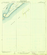
 1933 Karankawa Lake1933 Print · USGSThe Galveston coastline in the early 1930s is captured here, showing the unbridled geography of Galveston Island and the bay. Researchers can trace the original shoreline and water features like Karankawa Lake, Karankawa Point, and Lake Como.2 unique versions available
 - 1933 Map of San Luis Pass
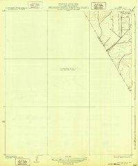
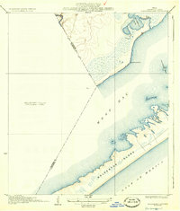
 1933 San Luis Pass1933 Print · USGSThe southwestern tip of Galveston Island is captured in the early 1930s, showing the maritime landscape before modern bridge connections. Trace the coastal defenses and tidal inlets of the era, from the San Luis Coast Guard station to the waters of West Bay.2 unique versions available
End of results
Showing maps 1-6 of 6
Top cities of Brazoria County
- Pearland historical maps
- Lake Jackson historical maps
- Alvin historical maps
- Angleton historical maps
- Iowa Colony historical maps
- Freeport historical maps
See more
Frequently asked questions
- What are the different types of historical maps available for Brazoria County?
- What is the oldest map of Brazoria County?
- Where can I purchase historical maps of Brazoria County for my home or office?
- Where can I download high-res historical maps of Brazoria County?
- Are there historical topographic maps available for Brazoria County?
- Is there historical aerial imagery available for Brazoria County?
- Where are historical maps of Brazoria County sourced from?