1960s Maps of Brazoria County, Texas
Explore 16 historic maps of Brazoria County from the 1960s. These maps offer a rare glimpse into what life looked like during the 1960s — showing old roads, neighborhoods, homes, and landmarks that have changed or disappeared over time.
Whether you're researching your family's past, planning a metal detecting trip, or studying how Brazoria County's landscape evolved across the 1960s, these high-resolution maps are a powerful tool for exploring the history of this region.
- Focus on a specific era: All maps on this page are from the 1960s, giving you a focused view of this time period.
- See what’s changed: Compare century-old streets, trails, and buildings to today's modern landscape using overlays and satellite layers.
- Research with precision: Use these maps for genealogy, historical research, land use analysis, or educational projects.
- View, download, or print: Maps are fully viewable online in high resolution, and can be downloaded or printed for your own records.
Start exploring Brazoria County's history through authentic maps from the 1960s. This is your window into the past.
Brazoria County, TX maps
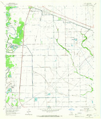
(16)- 1963 Map of Angleton, 1966 Print
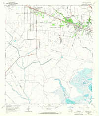
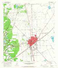 1963 Angleton1966 Print · USGSBrazoria County undergoes significant development in the early sixties as the oil industry and regional rail lines reshape the prairie. Researchers can trace family history at Burrel Chapel Cem or locate the former Texas Agricultural Experimental Station and Bailes Airfield.3 unique versions available
 - 1963 Map of Rosharon, 1966 Print
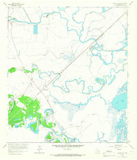
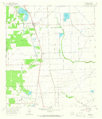 1963 Rosharon1966 Print · USGSBrazoria County in the early 1960s was a landscape where old Texas plantations and newer oil fields converged along the Missouri Pacific railroad. Genealogists can trace family roots at Daughters Cem and Pilgrim Cem, or locate the historic Chenango Plantation.2 unique versions available
 - 1963 Map of Liverpool, 1966 Print
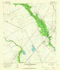 1963 Liverpool1966 Print · USGSBrazoria County’s coastal prairie comes alive in the mid-sixties as a landscape defined by water engineering and oil wealth. Trace the winding Chocolate Bayou past Liverpool and explore the industrial roots of the Danbury Dome Oil Field.3 unique versions available
 - 1963 Map of Mustang Bayou, 1966 Print
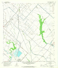 1963 Mustang Bayou1966 Print · USGSBrazoria and Galveston counties in the early 1960s show a landscape shaped by oil fields and coastal waterways. Genealogists and researchers can trace the Missouri Pacific rail line, locate the German Cem, or find early industrial sites like the Refinery.3 unique versions available
 - 1963 Map of Juliff, 1966 Print
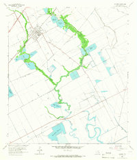
 1963 Juliff1966 Print · USGSThe coastal prairie of Brazoria and Fort Bend Counties in the early sixties shows a landscape defined by petroleum and rail. Genealogists and historians can locate family landmarks like Woods Cem and Sandy Point Cem near the Arcola Oil Field.2 unique versions available
 - 1963 Map of Jones Creek, 1966 Print
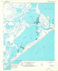
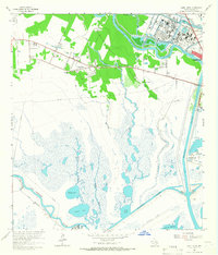 1963 Jones Creek1966 Print · USGSCoastal Brazoria County in the early 1960s reveals a landscape of marshy bayous and growing industry between two major rivers. Genealogists and researchers can locate the Velasco Cem, Gulf Prairie Ch, and the Austin Sch near the settlement of Jones Creek.2 unique versions available
 - 1963 Map of Hoskins Mound, 1966 Print
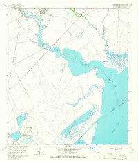 1963 Hoskins Mound1966 Print · USGSThe coastal marshlands of Brazoria County are shown here in the early 1960s as industrial operations began to reshape the landscape. Researchers can trace the development of Sulphur Wells at Hoskins Mound and the maritime traffic lanes along the Intracoastal Waterway.2 unique versions available
 - 1963 Map of Lake Jackson, 1966 Print
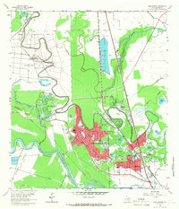 1963 Lake Jackson1966 Print · USGSIn the early 1960s, the Brazos River bottomlands saw the rapid growth of Lake Jackson and Clute amidst established correctional units. Researchers can trace local development through Lake Jackson, Lake Jackson Farms, and neighborhood landmarks like St Michaels Ch.4 unique versions available
 - 1963 Map of Sea Isle, 1966 Print
 1963 Sea Isle1966 Print · USGSGalveston Island shows its mid-century growth as new coastal communities emerge along the Gulf. Genealogists and historians can trace early developments at Sea Isle and Bay Harbor or locate family landmarks like the Fishing Cabins on Halls Bayou.3 unique versions available
 - 1963 Map of San Luis Pass, 1966 Print
 1963 San Luis Pass1966 Print · USGSThe southwestern tip of Galveston Island and the waters of San Luis Pass are captured here in the early 1960s. Genealogists and coastal historians can trace early island life near Bay Harbor and along West Beach.2 unique versions available
 - 1963 Map of Oyster Creek, 1966 Print
 1963 Oyster Creek1966 Print · USGSThe Brazoria County coast in the early sixties is a landscape of winding bayous and industrial salt and oil works. Genealogists can trace family landmarks like Hudgens Cem and Evergreen Ch near the settlement of Mims.3 unique versions available
 - 1963 Map of Danbury, 1966 Print
 1963 Danbury1966 Print · USGSCoastal Brazoria County in the early sixties is defined by its water-dependent industry and rail-connected settlements. Genealogists and historians can trace the growth of Danbury alongside the Missouri Pacific line and the numerous family-named landmarks like McCormack Reservoir and Peltier Lakes.2 unique versions available
 - 1964 Map of Freeport, 1966 Print
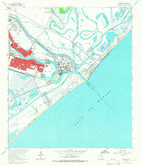 1964 Freeport1966 Print · USGSThe Texas Gulf Coast comes alive in the mid-1960s as Freeport expands its industrial reach at the mouth of the Brazos. Trace family roots and local history at Velasco Heights, West End Ch, or the Jane Long Sch.5 unique versions available
 - 1964 Map of Cedar Lakes East, 1966 Print
 1964 Cedar Lakes East1966 Print · USGSThe Brazoria coast in the mid-sixties reveals a landscape of tidal marshes and industrial waterways where the San Bernard River meets the sea. Genealogists and maritime historians can trace the isolated Ducroz Cem and the path of the Intracoastal Waterway through the wetlands.2 unique versions available
 - 1964 Map of Hitchcock, 1966 Print
 1964 Hitchcock1966 Print · USGSGalveston County’s industrial and coastal landscape is captured here in the mid-1960s, showing the intersection of petroleum production and community growth. Genealogists and historians can trace family locations near Alta Loma Cem, Crosby High Sch, and the extensive Sarah White Oil Field.4 unique versions available
 - 1965 Map of Christmas Point, 1966 Print
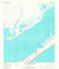
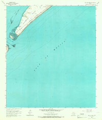
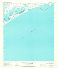
 1965 Christmas Point1966 Print · USGSThe Brazoria County coastline in the mid-sixties reveals a dynamic landscape of barrier islands and industrial navigation. Researchers can trace the path of the Intracoastal Waterway or locate local landmarks like the Landing Strip and Arcadia Reef.3 unique versions available
End of results
Showing maps 1-16 of 16
Top cities of Brazoria County
- Pearland historical maps
- Lake Jackson historical maps
- Alvin historical maps
- Angleton historical maps
- Iowa Colony historical maps
- Freeport historical maps
See more
Frequently asked questions
- What are the different types of historical maps available for Brazoria County?
- What is the oldest map of Brazoria County?
- Where can I purchase historical maps of Brazoria County for my home or office?
- Where can I download high-res historical maps of Brazoria County?
- Are there historical topographic maps available for Brazoria County?
- Is there historical aerial imagery available for Brazoria County?
- Where are historical maps of Brazoria County sourced from?