1910s Maps of Burleson County, Texas
Explore 2 historic maps of Burleson County from the 1910s. These maps offer a rare glimpse into what life looked like during the 1910s — showing old roads, neighborhoods, homes, and landmarks that have changed or disappeared over time.
Whether you're researching your family's past, planning a metal detecting trip, or studying how Burleson County's landscape evolved across the 1910s, these high-resolution maps are a powerful tool for exploring the history of this region.
- Focus on a specific era: All maps on this page are from the 1910s, giving you a focused view of this time period.
- See what’s changed: Compare century-old streets, trails, and buildings to today's modern landscape using overlays and satellite layers.
- Research with precision: Use these maps for genealogy, historical research, land use analysis, or educational projects.
- View, download, or print: Maps are fully viewable online in high resolution, and can be downloaded or printed for your own records.
Start exploring Burleson County's history through authentic maps from the 1910s. This is your window into the past.
Burleson County, TX maps
(2)- 1914 Map of Gay Hill
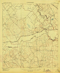 1914 Gay Hill1914 Print · USGSThe Brazos River valley in the early twentieth century shows a thriving rail-and-farm economy across three counties. Genealogists can trace family landmarks and rural school sites like Wiedes Store, Old Gay Hill, and the Allseeing Eye School.2 unique versions available
 - 1919 Map of Dime Box, 1956 Print
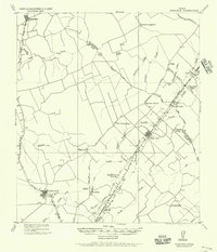 1919 Dime Box1956 Print · USGSLee County and the surrounding Texas Brazos Valley are shown here just after the Great War, during a period of shifting settlements. Genealogists can trace early homesteads and community hubs near Old Dime Box, Loebau, and Shady Grove School.
End of results
Showing maps 1-2 of 2
Top cities of Burleson County
Frequently asked questions
- What are the different types of historical maps available for Burleson County?
- What is the oldest map of Burleson County?
- Where can I purchase historical maps of Burleson County for my home or office?
- Where can I download high-res historical maps of Burleson County?
- Are there historical topographic maps available for Burleson County?
- Is there historical aerial imagery available for Burleson County?
- Where are historical maps of Burleson County sourced from?