1960s Maps of Burleson County, Texas
Explore 14 historic maps of Burleson County from the 1960s. These maps offer a rare glimpse into what life looked like during the 1960s — showing old roads, neighborhoods, homes, and landmarks that have changed or disappeared over time.
Whether you're researching your family's past, planning a metal detecting trip, or studying how Burleson County's landscape evolved across the 1960s, these high-resolution maps are a powerful tool for exploring the history of this region.
- Focus on a specific era: All maps on this page are from the 1960s, giving you a focused view of this time period.
- See what’s changed: Compare century-old streets, trails, and buildings to today's modern landscape using overlays and satellite layers.
- Research with precision: Use these maps for genealogy, historical research, land use analysis, or educational projects.
- View, download, or print: Maps are fully viewable online in high resolution, and can be downloaded or printed for your own records.
Start exploring Burleson County's history through authentic maps from the 1960s. This is your window into the past.
Burleson County, TX maps
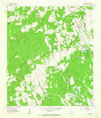
(14)- 1960 Map of Lyons, 1962 Print
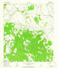
 1960 Lyons1962 Print · USGSThe community of Lyons is captured here in the early 1960s, centered on the Gulf Colorado and Santa Fe railroad. Local researchers can trace family landmarks like the Lawrence Cem and Lone Oak Ch along the banks of Davidson Creek.2 unique versions available
 - 1960 Map of Snook, 1962 Print
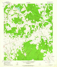
 1960 Snook1962 Print · USGSBurleson County in the early 1960s was a landscape of remote settlements and rail-dependent agriculture centered on the Snook community. Genealogists and local researchers can trace historic sites like Money Chapel, the Snook Cem, and the Gulf Colorado and Santa Fe railroad line.2 unique versions available
 - 1960 Map of Tanglewood, 1962 Print
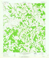
 1960 Tanglewood1962 Print · USGSLee County as it appeared in the early 1960s was a landscape defined by the Southern Pacific rail line and rural church communities. Genealogists can locate family burial sites at Mt Zion Cem or German Cem and trace the paths of East Yegua Creek and its many branches.3 unique versions available
 - 1960 Map of Frenstat, 1963 Print
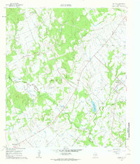
 1960 Frenstat1963 Print · USGSBurleson County, Texas, was a patchwork of small agricultural settlements and wooded creeks in the early sixties. Researchers can trace the rail corridors of the Southern Pacific and locate family sites near Frenstat and the Beaird Cem.2 unique versions available
 - 1960 Map of Deanville, 1963 Print
 1960 Deanville1963 Print · USGSBurleson and Lee counties in the early sixties reveal a landscape of rural schoolhouses and family cemeteries along the railroad. Genealogists can locate Sulphur Spring School, San Antonio Prairie Cemetery, and the original site of Old Dime Box.3 unique versions available
 - 1961 Map of Caldwell, 1963 Print
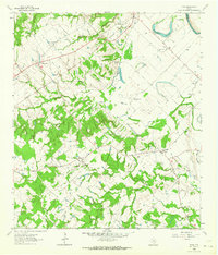
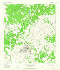 1961 Caldwell1963 Print · USGSCaldwell was a bustling rail hub in the early sixties where major Texas lines crossed amidst a landscape of rural schools and Czech-influenced settlements. Researchers can locate the Hus Sch, the New Tabor Cem, and trace the path of the Old Railroad Grade.2 unique versions available
 - 1961 Map of Mumford, 1964 Print
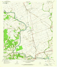 1961 Mumford1964 Print · USGSThe Brazos River valley in the early sixties is a landscape of rural junctions and historic outposts at the meeting point of four counties. Researchers can locate the Fort Tenoxtitlan (Site), the rail sidings at Mudville, and local landmarks like Smith Sch.3 unique versions available
 - 1961 Map of Wellborn, 1965 Print
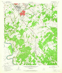 1961 Wellborn1965 Print · USGSBrazos County during the early 1960s showcases the growing footprint of Texas A & M University alongside traditional rail-side settlements. Genealogists and historians can trace rural life through landmarks like Salem Ch, the College Station Cem, and old stops along the Missouri Pacific railroad.4 unique versions available
 - 1962 Map of Goodwill, 1963 Print
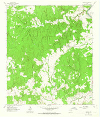 1962 Goodwill1963 Print · USGSThe rural borderlands of Burleson and Milam counties are captured here in the early 1960s, centered on the community of Hix. Genealogists and local historians can trace the foundations of this area through St Mathews Ch, the Hix Cem, and family-named hollows like Bailey Hollow.2 unique versions available
 - 1962 Map of Chriesman, 1964 Print
 1962 Chriesman1964 Print · USGSSettled along the tracks in Burleson County during the early sixties, this area shows a landscape shaped by rail and creek. Genealogists can trace family landmarks like Chriesman Cem, Liberty Ch, and the old Shiloh Sch.3 unique versions available
 - 1962 Map of Tunis, 1964 Print
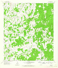
 1962 Tunis1964 Print · USGSBurleson County in the early sixties reveals a landscape of river-bottom farms and small rail-stop communities. Genealogists and historians can trace family roots through sites like Salem Cem, the New Jerusalem Ch, and the settlement of Cooks Point.2 unique versions available
 - 1962 Map of Milano, 1964 Print
 1962 Milano1964 Print · USGSRailroad history and rural community life converge in early 1960s Texas at the busy junction of the Missouri Pacific and Santa Fe lines. Local researchers can trace family roots through landmarks like Sand Grove Ch, Hurt Cem, and the settlement at Elevation.2 unique versions available
 - 1962 Map of Hicks, 1964 Print
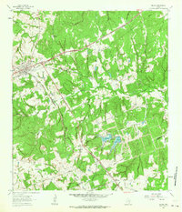
 1962 Hicks1964 Print · USGSThe tri-county junction of Milam, Lee, and Burleson counties is captured in the early sixties as a landscape of rural industry and community. Researchers can trace family history at Harmony Cem or locate the old Railroad Grade and Hicks Mine.2 unique versions available
 - 1962 Map of Chances Store, 1964 Print
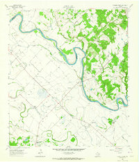 1962 Chances Store1964 Print · USGSBrazos and Burleson counties are shown here in the early sixties as the Brazos River meanders through a landscape of rural stores and family farms. Researchers can locate the Newsome Cemetery, Jones High School, and community landmarks like Chances Store and Grant.5 unique versions available
End of results
Showing maps 1-14 of 14
Top cities of Burleson County
Frequently asked questions
- What are the different types of historical maps available for Burleson County?
- What is the oldest map of Burleson County?
- Where can I purchase historical maps of Burleson County for my home or office?
- Where can I download high-res historical maps of Burleson County?
- Are there historical topographic maps available for Burleson County?
- Is there historical aerial imagery available for Burleson County?
- Where are historical maps of Burleson County sourced from?