1970s Maps of Burleson County, Texas
Explore 2 historic maps of Burleson County from the 1970s. These maps offer a rare glimpse into what life looked like during the 1970s — showing old roads, neighborhoods, homes, and landmarks that have changed or disappeared over time.
Whether you're researching your family's past, planning a metal detecting trip, or studying how Burleson County's landscape evolved across the 1970s, these high-resolution maps are a powerful tool for exploring the history of this region.
- Focus on a specific era: All maps on this page are from the 1970s, giving you a focused view of this time period.
- See what’s changed: Compare century-old streets, trails, and buildings to today's modern landscape using overlays and satellite layers.
- Research with precision: Use these maps for genealogy, historical research, land use analysis, or educational projects.
- View, download, or print: Maps are fully viewable online in high resolution, and can be downloaded or printed for your own records.
Start exploring Burleson County's history through authentic maps from the 1970s. This is your window into the past.
Burleson County, TX maps
(2)- 1971 Map of Flag Pond, 1973 Print
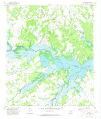 1971 Flag Pond1973 Print · USGSTexas lake country comes into focus in the early 1970s as the waters of Somerville Lake define the border between Burleson and Washington Counties. Local historians can trace the rural landscape surrounding the reservoir, locating landmarks like Post Oak School, St Mary Ch, and the namesake Flag Pond.2 unique versions available
 - 1971 Map of Somerville, 1974 Print
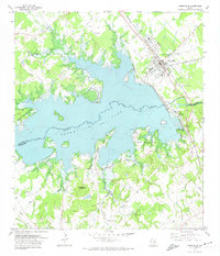 1971 Somerville1974 Print · USGSSomerville and the surrounding Brazos Valley uplands are captured here in the early seventies, following the inundation of the Yegua Creek basin. Researchers can trace the extensive Atchison Topeka and Santa Fe rail yards and rural family sites like Schoppe Cem or Rehburg.3 unique versions available
End of results
Showing maps 1-2 of 2
Top cities of Burleson County
Frequently asked questions
- What are the different types of historical maps available for Burleson County?
- What is the oldest map of Burleson County?
- Where can I purchase historical maps of Burleson County for my home or office?
- Where can I download high-res historical maps of Burleson County?
- Are there historical topographic maps available for Burleson County?
- Is there historical aerial imagery available for Burleson County?
- Where are historical maps of Burleson County sourced from?