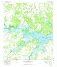
1971 Map of Flag Pond
USGS Topo · Published 1973About this map
Somerville Lake dominates the central landscape of this 1970s survey, where the waters of Yegua Creek and its various forks converge. The reservoir's irregular shoreline creates a complex system of inlets and peninsulas, now preserved as Nails Creek State Park and Birch Creek State Park. Before these waters were managed, the area was defined by its waterlogged depressions, most notably Flag Pond, which remains a prominent feature just west of the main lake body.
Find a feature on this map
25 named features on this map. Tap any name to fly to it.
Don’t see what you’re looking for? This feature index may not catch every label — zoom into the map to look around manually.
Map Details
Editions of this 1971 Flag Pond Map
2 editions found
Other maps of this area

1919 · Giddings
USGS Topo · 1:62,500

1919 · Dime Box
USGS Topo · 1:62,500

1954 · Austin
USGS Topo · 1:250,000

1956 · Somerville
USGS Topo · 1:62,500

1958 · Ledbetter
USGS Topo · 1:24,000

1958 · Carmine
USGS Topo · 1:24,000

1958 · Burton
USGS Topo · 1:24,000

1959 · Flag Pond
USGS Topo · 1:24,000

1959 · Somerville
USGS Topo · 1:24,000
1959 · Dime Box
USGS Topo · 1:24,000