1960s Maps of Marble Falls, Texas
Explore 4 historic maps of Marble Falls from the 1960s. These maps offer a rare glimpse into what life looked like during the 1960s — showing old roads, neighborhoods, homes, and landmarks that have changed or disappeared over time.
Whether you're researching your family's past, planning a metal detecting trip, or studying how Marble Falls's landscape evolved across the 1960s, these high-resolution maps are a powerful tool for exploring the history of this region.
- Focus on a specific era: All maps on this page are from the 1960s, giving you a focused view of this time period.
- See what’s changed: Compare century-old streets, trails, and buildings to today's modern landscape using overlays and satellite layers.
- Research with precision: Use these maps for genealogy, historical research, land use analysis, or educational projects.
- View, download, or print: Maps are fully viewable online in high resolution, and can be downloaded or printed for your own records.
Start exploring Marble Falls's history through authentic maps from the 1960s. This is your window into the past.
Marble Falls, TX maps
(4)- 1967 Map of Round Mountain, 1969 Print
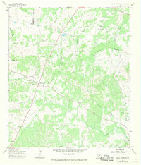 1967 Round Mountain1969 Print · USGSThe Texas Hill Country at the end of the 1960s comes into focus at the intersection of Blanco, Burnet, and Llano counties. Researchers can trace land boundaries and rural development near Round Mountain, the Round Mountain Cem, and Cypress Mill.2 unique versions available
 - 1967 Map of Longhorn Cavern, 1969 Print
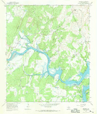
 1967 Longhorn Cavern1969 Print · USGSThe Burnet County Hill Country is captured here in the late sixties as the region's parklands and rail lines defined the local economy. Researchers can trace family sites like Tobey Cem and the small settlements of Fairland and Sudduth along the Southern Pacific tracks.3 unique versions available
 - 1967 Map of Smithwick, 1969 Print
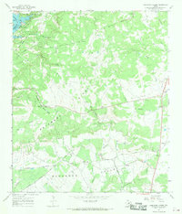
 1967 Smithwick1969 Print · USGSThe Colorado River valley in Burnet County is shown here during the late 1960s as the landscape adapted to the presence of the lake. Local researchers can trace numerous family burial sites like Richland Cem and Burnam Cem or locate the Spicewood Beach Landing Strip.3 unique versions available
 - 1967 Map of Marble Falls, 1971 Print
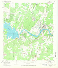 1967 Marble Falls1971 Print · USGSMarble Falls and the surrounding Hill Country are captured here in the late sixties as the region's hydroelectric and quarrying industries matured. Researchers can trace the river's transformation at the Alvin Wirtz Dam or locate family history at Konvicka Cem and Fox Cem.2 unique versions available
End of results
Showing maps 1-4 of 4
Top cities near Marble Falls
- Burnet historical maps
- Horseshoe Bay historical maps
- Granite Shoals historical maps
- Meadowlakes historical maps
- Bertram historical maps
- Cottonwood Shores historical maps
See more
Frequently asked questions
- What are the different types of historical maps available for Marble Falls?
- What is the oldest map of Marble Falls?
- Where can I purchase historical maps of Marble Falls for my home or office?
- Where can I download high-res historical maps of Marble Falls?
- Are there historical topographic maps available for Marble Falls?
- Is there historical aerial imagery available for Marble Falls?
- Where are historical maps of Marble Falls sourced from?