1920s Maps of Coke County, Texas
Explore 4 historic maps of Coke County from the 1920s. These maps offer a rare glimpse into what life looked like during the 1920s — showing old roads, neighborhoods, homes, and landmarks that have changed or disappeared over time.
Whether you're researching your family's past, planning a metal detecting trip, or studying how Coke County's landscape evolved across the 1920s, these high-resolution maps are a powerful tool for exploring the history of this region.
- Focus on a specific era: All maps on this page are from the 1920s, giving you a focused view of this time period.
- See what’s changed: Compare century-old streets, trails, and buildings to today's modern landscape using overlays and satellite layers.
- Research with precision: Use these maps for genealogy, historical research, land use analysis, or educational projects.
- View, download, or print: Maps are fully viewable online in high resolution, and can be downloaded or printed for your own records.
Start exploring Coke County's history through authentic maps from the 1920s. This is your window into the past.
Coke County, TX maps
(4)- 1921 Map of Bronte
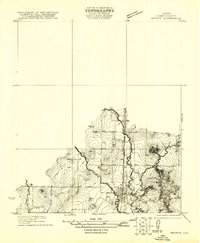 1921 Bronte1921 Print · USGSCoke County ranching and rail life are centered around the town of Bronte during the early 1920s. Researchers can trace the path of the Kansas City Mexico and Orient railroad or locate rural landmarks like Turkey Creek School and the local Cem.
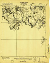
 - 1921 Map of Baker Flat
 1921 Baker Flat1921 Print · USGSRunnels County ranch lands and rural school districts are captured in this early 1920s survey. Researchers can locate the Red Bank School and trace the drainage of Antelope Creek through the Baker Flat area.
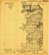
 - 1921 Map of Maverick
 1921 Maverick1921 Print · USGSThe rural landscape of Runnels and Coke County is captured here in the early 1920s, showing the early infrastructure of the Maverick area. Researchers can locate the Brookshire School and trace the original courses of Oak Creek and the Colorado River.
 - 1921 Map of Mays School
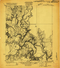
 1921 Mays School1921 Print · USGSCoke County's river-cut landscape is captured here in the early 1920s as the railroad established new routes through West Texas. Researchers can locate the rural Mays School and trace the original path of the Kansas City Mexico and Orient rail line near Kickapoo Creek.
End of results
Showing maps 1-4 of 4
Top cities of Coke County
Frequently asked questions
- What are the different types of historical maps available for Coke County?
- What is the oldest map of Coke County?
- Where can I purchase historical maps of Coke County for my home or office?
- Where can I download high-res historical maps of Coke County?
- Are there historical topographic maps available for Coke County?
- Is there historical aerial imagery available for Coke County?
- Where are historical maps of Coke County sourced from?