1930s Maps of Port Bolivar, Texas
Explore 2 historic maps of Port Bolivar from the 1930s. These maps offer a rare glimpse into what life looked like during the 1930s — showing old roads, neighborhoods, homes, and landmarks that have changed or disappeared over time.
Whether you're researching your family's past, planning a metal detecting trip, or studying how Port Bolivar's landscape evolved across the 1930s, these high-resolution maps are a powerful tool for exploring the history of this region.
- Focus on a specific era: All maps on this page are from the 1930s, giving you a focused view of this time period.
- See what’s changed: Compare century-old streets, trails, and buildings to today's modern landscape using overlays and satellite layers.
- Research with precision: Use these maps for genealogy, historical research, land use analysis, or educational projects.
- View, download, or print: Maps are fully viewable online in high resolution, and can be downloaded or printed for your own records.
Start exploring Port Bolivar's history through authentic maps from the 1930s. This is your window into the past.
Port Bolivar, TX maps
(2)- 1932 Map of Bolivar Point
 1932 Bolivar Point1932 Print · USGSThe tip of the Bolivar Peninsula is captured in the early 1930s just as aerial surveying began to transform coastal mapping. Researchers can trace the path of the G C & S F railroad near Bolivar Point or study the shoals of Hannah Reef.
 - 1933 Map of Bolivar Point
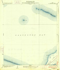 1933 Bolivar Point1933 Print · USGSGalveston Bay and the Bolivar Peninsula are captured here in the early 1930s as vital maritime and rail corridors. Researchers can trace the path of the G C & S F railroad toward Bolivar Point or examine the reach of the Texas City Dike.2 unique versions available
End of results
Showing maps 1-2 of 2
Top cities near Port Bolivar
- Pasadena historical maps
- Galveston historical maps
- Texas City historical maps
- La Marque historical maps
- Seabrook historical maps
- Bacliff historical maps
See more
Frequently asked questions
- What are the different types of historical maps available for Port Bolivar?
- What is the oldest map of Port Bolivar?
- Where can I purchase historical maps of Port Bolivar for my home or office?
- Where can I download high-res historical maps of Port Bolivar?
- Are there historical topographic maps available for Port Bolivar?
- Is there historical aerial imagery available for Port Bolivar?
- Where are historical maps of Port Bolivar sourced from?