1960s Maps of Kingsbury, Texas
Explore 3 historic maps of Kingsbury from the 1960s. These maps offer a rare glimpse into what life looked like during the 1960s — showing old roads, neighborhoods, homes, and landmarks that have changed or disappeared over time.
Whether you're researching your family's past, planning a metal detecting trip, or studying how Kingsbury's landscape evolved across the 1960s, these high-resolution maps are a powerful tool for exploring the history of this region.
- Focus on a specific era: All maps on this page are from the 1960s, giving you a focused view of this time period.
- See what’s changed: Compare century-old streets, trails, and buildings to today's modern landscape using overlays and satellite layers.
- Research with precision: Use these maps for genealogy, historical research, land use analysis, or educational projects.
- View, download, or print: Maps are fully viewable online in high resolution, and can be downloaded or printed for your own records.
Start exploring Kingsbury's history through authentic maps from the 1960s. This is your window into the past.
Kingsbury, TX maps
(3)- 1964 Map of Kingsbury, 1965 Print
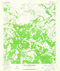 1964 Kingsbury1965 Print · USGSGuadalupe and Caldwell Counties are captured here in the mid-1960s, showing the agricultural and transit landscape of the San Marcos River valley. Genealogists and local historians can trace the Southern Pacific line through Kingsbury and locate the Appling Cem or Sweet Canaan Ch.3 unique versions available
 - 1964 Map of Darst Creek, 1965 Print
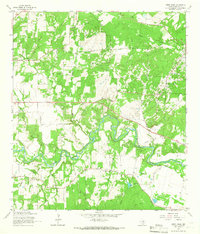 1964 Darst Creek1965 Print · USGSGuadalupe County in the mid-sixties reveals a landscape defined by the winding Guadalupe River and the local petroleum industry. Researchers can trace rural lineages at Eden Cem or locate the historic New Salem Ch and the area's extensive Oil Field infrastructure.3 unique versions available
 - 1964 Map of Luling, 1966 Print
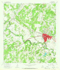 1964 Luling1966 Print · USGSLuling and the surrounding oil fields are captured here in the mid-1960s as the regional energy and rail economy thrived. Genealogists can locate family landmarks such as Highsmith Cemeteries, Prairie Lea Cem, and the Rosenwald Sch.3 unique versions available
End of results
Showing maps 1-3 of 3
Top cities near Kingsbury
- San Marcos historical maps
- Seguin historical maps
- Lockhart historical maps
- Luling historical maps
- Martindale historical maps
- Staples historical maps
Frequently asked questions
- What are the different types of historical maps available for Kingsbury?
- What is the oldest map of Kingsbury?
- Where can I purchase historical maps of Kingsbury for my home or office?
- Where can I download high-res historical maps of Kingsbury?
- Are there historical topographic maps available for Kingsbury?
- Is there historical aerial imagery available for Kingsbury?
- Where are historical maps of Kingsbury sourced from?