1990s Maps of Hardin County, Texas
Explore 3 historic maps of Hardin County from the 1990s. These maps offer a rare glimpse into what life looked like during the 1990s — showing old roads, neighborhoods, homes, and landmarks that have changed or disappeared over time.
Whether you're researching your family's past, planning a metal detecting trip, or studying how Hardin County's landscape evolved across the 1990s, these high-resolution maps are a powerful tool for exploring the history of this region.
- Focus on a specific era: All maps on this page are from the 1990s, giving you a focused view of this time period.
- See what’s changed: Compare century-old streets, trails, and buildings to today's modern landscape using overlays and satellite layers.
- Research with precision: Use these maps for genealogy, historical research, land use analysis, or educational projects.
- View, download, or print: Maps are fully viewable online in high resolution, and can be downloaded or printed for your own records.
Start exploring Hardin County's history through authentic maps from the 1990s. This is your window into the past.
Hardin County, TX maps
(3)- 1992 Map of Livingston
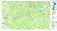 1992 Livingston1992 Print · USGSSoutheast Texas at the start of the nineties reveals a landscape of deep pine forests, oil fields, and historic rural communities. Researchers can locate family landmarks like Holly Grove Cem and Wildwood Sch, or trace the winding Angelina River near B A Steinhagen Lake.
 - 1993 Map of Voth
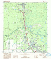 1993 Voth1993 Print · USGSCoastal Texas wetlands and suburban growth meet in the early nineties as the Beaumont area expands northward. Researchers can trace historical footprints through the Arriola Oil Field, the Rosedale Sch, and the winding Neches River.
 - 1993 Map of Pine Forest
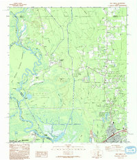 1993 Pine Forest1993 Print · USGSThe Neches River bottomlands and the growth of Vidor define this Southeast Texas landscape in the early nineties. Researchers can trace the layout of Restlawn Memorial Park (Cem), old crossings like Lawson Crossing, and the wild edges of the Big Thicket National Preserve.
End of results
Showing maps 1-3 of 3
Top cities of Hardin County
- Lumberton historical maps
- Silsbee historical maps
- Kountze historical maps
- Sour Lake historical maps
- Rose Hill Acres historical maps
Frequently asked questions
- What are the different types of historical maps available for Hardin County?
- What is the oldest map of Hardin County?
- Where can I purchase historical maps of Hardin County for my home or office?
- Where can I download high-res historical maps of Hardin County?
- Are there historical topographic maps available for Hardin County?
- Is there historical aerial imagery available for Hardin County?
- Where are historical maps of Hardin County sourced from?