1980s Maps of Harris County, Texas
Explore 30 historic maps of Harris County from the 1980s. These maps offer a rare glimpse into what life looked like during the 1980s — showing old roads, neighborhoods, homes, and landmarks that have changed or disappeared over time.
Whether you're researching your family's past, planning a metal detecting trip, or studying how Harris County's landscape evolved across the 1980s, these high-resolution maps are a powerful tool for exploring the history of this region.
- Focus on a specific era: All maps on this page are from the 1980s, giving you a focused view of this time period.
- See what’s changed: Compare century-old streets, trails, and buildings to today's modern landscape using overlays and satellite layers.
- Research with precision: Use these maps for genealogy, historical research, land use analysis, or educational projects.
- View, download, or print: Maps are fully viewable online in high resolution, and can be downloaded or printed for your own records.
Start exploring Harris County's history through authentic maps from the 1980s. This is your window into the past.
Harris County, TX maps
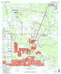
(30)- 1982 Map of Clodine
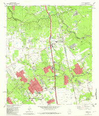
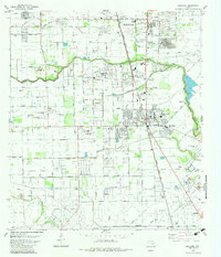
 1982 Clodine1982 Print · USGSFort Bend and Harris counties were on the cusp of rapid suburban change in the early eighties. Genealogists and researchers can trace the footprint of the Jester State Prison Farm, find Magee Cemetery, or locate the rural Clodine crossroads.
 - 1982 Map of Humble
 1982 Humble1982 Print · USGSNorth of Houston in the early eighties, the landscape is defined by the growth of modern aviation and expanding suburbs. Researchers can trace family roots through numerous sites like Brookside Memorial Park (Cem), Bordersville, and Mac Arthur High Sch.
 - 1982 Map of Crosby
 1982 Crosby1982 Print · USGSEastern Harris County in the early eighties shows the expansion of lakeside communities alongside established railroad towns. Genealogists and historians can trace family plots at Simms Cem, locate the old High Sch in Crosby, and see the developing Newport area.
 - 1982 Map of Mont Belvieu
 1982 Mont Belvieu1982 Print · USGSThe industrial and residential growth of the Texas Gulf Coast is captured here in the early eighties. Genealogists and historians can trace family sites like Busch Cem and Fisher Cem or locate the sprawling Oil and Gas Field and refinery works.
 - 1982 Map of Maedan
 1982 Maedan1982 Print · USGSSoutheast Texas in the early eighties shows a shifting landscape where sprawling river bottomlands meet growing residential communities. Genealogists and local historians can locate several family burial grounds like Enloe Cem, early schools including Teague Sch, and the rail-side community of Bordersville.
 - 1982 Map of Spring
 1982 Spring1982 Print · USGSNorth of Houston in the early 1980s, the Spring area was rapidly evolving from a rail-stop settlement into a sprawling suburban hub. Genealogists and historians can trace family-named sites like Ehrhardt Cem and Glameyer Cem alongside newer landmarks like Skyline Airport.
 - 1982 Map of Harmaston
 1982 Harmaston1982 Print · USGSNortheast of Houston in the early 1980s, this area balances burgeoning residential developments with vital water and energy infrastructure. Genealogists and historians can trace the Old Pacific Railroad Grade, locate the Harrington Cem, and see the extent of the Riverside Oil Field.
 - 1982 Map of Morgans Point
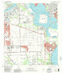
 1982 Morgans Point1982 Print · USGSBaytown and its surrounding coastal communities are shown here at the start of the 1980s, balancing industrial expansion with residential life. Genealogists and historians can trace neighborhood developments around Lee High Sch, the Hill of Rest Cem, and the specialized maritime docks at Barbours Cut.
 - 1982 Map of Sheeks
 1982 Sheeks1982 Print · USGSCoastal Texas industry and rural life meet in the early eighties as petroleum production and complex canal systems reshape the Liberty County landscape. Genealogists and historians can locate the Harvey Cem, the Esperson D.O.M.E. Oil Field, and the Sheeks rail siding.
 - 1982 Map of League City
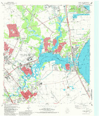 1982 League City1982 Print · USGSThe coastal corridor south of Houston was a hub of aerospace innovation and maritime industry in the early eighties. Researchers can locate the NASA Space Center, the Houston Gulf Airport, and local landmarks like Fairview Cem or the Southern Pacific tracks.3 unique versions available
 - 1982 Map of Bacliff
 1982 Bacliff1982 Print · USGSUpper Galveston Bay and the Texas coast come alive in this early eighties survey of the bustling Houston maritime corridor. Genealogists and local historians can trace the development of Bacliff, San Leon, and Seabrook alongside the heavy industrial footprint of the Oil Field.
 - 1982 Map of Alief
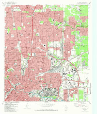
 1982 Alief1982 Print · USGSSouthwest Houston was undergoing a massive suburban transformation in the early eighties. Genealogists and historians can trace the development of Alief and Stafford, or locate family sites near Riceville Cem and Andrau Airpark.2 unique versions available
 - 1982 Map of Satsuma
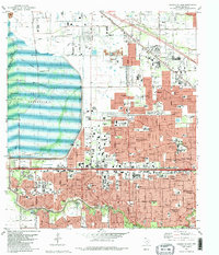
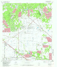 1982 Satsuma1982 Print · USGSNorthwest Harris County is seen during its rapid early 1980s expansion, as new subdivisions began to surround established rural landmarks. Genealogists can locate family sites like Dowdell Cem and Perry Cem among developments like Jersey Village.2 unique versions available
 - 1982 Map of Hedwig Village
 1982 Hedwig Village1982 Print · USGSWest Houston was rapidly transforming in the early eighties as residential developments filled the spaces between the Memorial Villages. Genealogists and local historians can trace the growth of Hedwig Village and Fairbanks, or locate landmarks like Buffalo Bayou and Tully Stadium.2 unique versions available
 - 1982 Map of La Porte, 1983 Print
 1982 La Porte1983 Print · USGSThe industrial and maritime heart of the Texas coast comes into focus in the early eighties as the ship channel drives the local economy. Trace family history and regional growth at La Porte, San Jacinto State Park, and the Wooster Cem.
 - 1982 Map of Houston Heights, 1983 Print
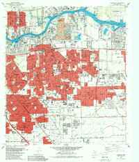
 1982 Houston Heights1983 Print · USGSHouston and its northwest suburbs are captured in the early eighties as the urban grid densified around historic rail corridors. Researchers can trace family sites near Houston Heights or locate historic burial grounds like Glenwood Cemetery and Hollywood Cem.
 - 1982 Map of Jacinto City, 1983 Print
 1982 Jacinto City1983 Print · USGSEastern Harris County in the early eighties shows a dense network of expanding suburbs and industrial hubs near the ship channel. Genealogists and local historians can trace family locations through numerous named schools like Cimarron Sch and landmarks like Bradshaw Cem or the Sheldon State Fish Hatchery.2 unique versions available
 - 1982 Map of Park Place, 1983 Print
 1982 Park Place1983 Print · USGSSoutheastern Houston and the Ship Channel area are shown in high detail during the early eighties, reflecting a period of intense industrial and suburban growth. Researchers can trace local history through the William P Hobby Airport, the University of Houston campus, and the Municipal Prison Farm.2 unique versions available
 - 1982 Map of Freindswood, 1983 Print
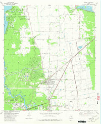
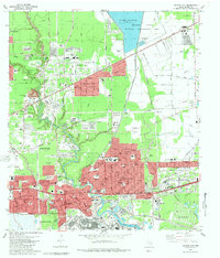
 1982 Freindswood1983 Print · USGSSoutheast Texas at the start of the eighties shows a landscape of rapid suburban growth and active energy production. Genealogists and local historians can trace the development of Wedgewood Village and Forest Bend alongside the Hastings Oil Field and Ellington Air Force Base.2 unique versions available
 - 1982 Map of Pearland, 1983 Print
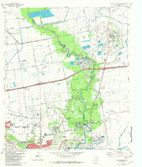
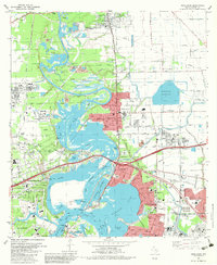
 1982 Pearland1983 Print · USGSPearland and the northern Brazoria County border are captured here in the early eighties as suburban growth begins to encircle the local oil fields. Researchers can locate family plots at South Park Cemetery or trace the early runways of Pearland Airport and Skyway Manor Airport.
 - 1982 Map of Settegast, 1983 Print
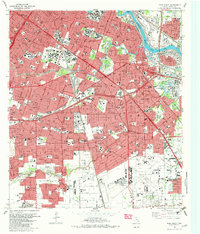
 1982 Settegast1983 Print · USGSHouston and its industrial rail corridors are captured in the early eighties as neighborhoods expanded around the massive Settegast Yards. Trace local family history through dozens of landmarks like Oak Park Cemetery and St Elizabeth Hospital.2 unique versions available
 - 1982 Map of Pasadena, 1983 Print
 1982 Pasadena1983 Print · USGSGreater Houston experienced significant industrial and suburban maturation by the early eighties, centered on the vital shipping corridors. Researchers can trace family roots through neighborhood landmarks like Crown Hill Cem or locate former aviation sites such as Genoa Airport.
 - 1982 Map of Almeda, 1983 Print
 1982 Almeda1983 Print · USGSThe southern reaches of the Houston area were rapidly modernizing in the early eighties as residential growth met established rural settlements. Researchers can trace the development of Almeda and Fresno alongside sites like the Blue Ridge State Prison Farm and Beth Jacob Cem.
 - 1982 Map of Highlands, 1983 Print
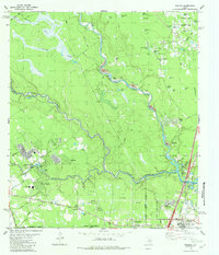
 1982 Highlands1983 Print · USGSThe industrial and historical heart of the Texas coast comes into focus in the early eighties at the confluence of the San Jacinto River and Buffalo Bayou. Trace local heritage at the San Jacinto Monument, the De Zavala Cem, or the old streets of Lynchburg.2 unique versions available
 - 1982 Map of Bellaire, 1983 Print
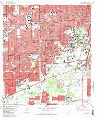 1982 Bellaire1983 Print · USGSSouthwest Houston and Bellaire are shown at a peak of late-century expansion, dominated by new highway loops and major medical hubs. Local historians can trace the development of the Astrodome complex and numerous schools like Madison High Sch and Lamar High Sch.
Showing maps 1-25 of 30
Top cities of Harris County
- Houston historical maps
- Pasadena historical maps
- Cypress historical maps
- Atascocita historical maps
- Baytown historical maps
- Spring historical maps
See more
Frequently asked questions
- What are the different types of historical maps available for Harris County?
- What is the oldest map of Harris County?
- Where can I purchase historical maps of Harris County for my home or office?
- Where can I download high-res historical maps of Harris County?
- Are there historical topographic maps available for Harris County?
- Is there historical aerial imagery available for Harris County?
- Where are historical maps of Harris County sourced from?