1960s Maps of Harris County, Texas
Explore 25 historic maps of Harris County from the 1960s. These maps offer a rare glimpse into what life looked like during the 1960s — showing old roads, neighborhoods, homes, and landmarks that have changed or disappeared over time.
Whether you're researching your family's past, planning a metal detecting trip, or studying how Harris County's landscape evolved across the 1960s, these high-resolution maps are a powerful tool for exploring the history of this region.
- Focus on a specific era: All maps on this page are from the 1960s, giving you a focused view of this time period.
- See what’s changed: Compare century-old streets, trails, and buildings to today's modern landscape using overlays and satellite layers.
- Research with precision: Use these maps for genealogy, historical research, land use analysis, or educational projects.
- View, download, or print: Maps are fully viewable online in high resolution, and can be downloaded or printed for your own records.
Start exploring Harris County's history through authentic maps from the 1960s. This is your window into the past.
Harris County, TX maps
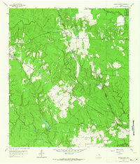
(25)- 1960 Map of Waller, 1961 Print
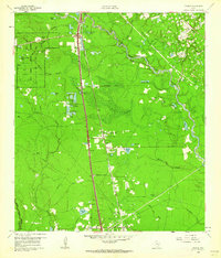
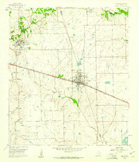 1960 Waller1961 Print · USGSThe Waller and Prairie View area at the dawn of the 1960s reveals a landscape of growing educational institutions and vital rail corridors. Researchers can trace the boundaries of Prairie View A & M College and locate family history at Waller Cem or Mathis Cem.4 unique versions available
 - 1960 Map of Waller NW, 1962 Print
 1960 Waller NW1962 Print · USGSThe rural borderlands of Waller and Harris counties are captured here in the early sixties, showing a landscape of family farms and creek bottoms. You can trace the community heart of the era through sites like Community Hall, Reida Prairie Ch, and Rosenau Cem.2 unique versions available
 - 1960 Map of Spring, 1962 Print
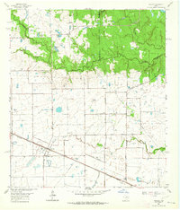
 1960 Spring1962 Print · USGSNorthern Harris County is captured here just as the rural oil-and-rail economy began to transition toward modern suburbia. Genealogists can locate family burial sites like Budde Cem and Ehrhardt Cem alongside the old Missouri Pacific line.2 unique versions available
 - 1960 Map of Huffman, 1962 Print
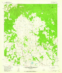
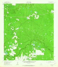
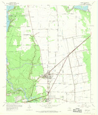
 1960 Huffman1962 Print · USGSNortheast Harris County in the early sixties was a landscape of bayous and rail lines at the edge of the rising Houston Lake. Genealogists and local historians can trace the foundations of Huffman, locating the Huffman School, St Annes Church, and the historic Atascocita Road.4 unique versions available
 - 1961 Map of Tamina, 1962 Print
 1961 Tamina1962 Print · USGSSouthern Montgomery County in the early sixties is a landscape of timber and oil, dominated by the West Fork San Jacinto River. Researchers can trace the roots of local communities at Tamina, locate family plots in the Tamina Cem, and explore the rail-side growth near Rayford.4 unique versions available
 - 1961 Map of Moonshine Hill, 1962 Print
 1961 Moonshine Hill1962 Print · USGSHarris and Montgomery counties appear at a crossroads in the early sixties as oil production and suburban growth meet the San Jacinto riverfront. Researchers can trace family roots at White Oak Cem, locate the wells of Riverside Field, or find early subdivisions like Walden Woods.4 unique versions available
 - 1961 Map of Maedan, 1962 Print
 1961 Maedan1962 Print · USGSThe Montgomery and Harris County borderlands come alive in this early 1960s survey, showing the confluence of river bottomlands and emerging rail-side communities. Trace the roots of Bordersville and Maedan or locate family markers at Enloe Cem and Tetter Cem.2 unique versions available
 - 1961 Map of Mont Belvieu, 1964 Print
 1961 Mont Belvieu1964 Print · USGSCoastal Texas industry and settlement meet along the Harris-Chambers county line in the early sixties. Researchers can trace family history at Barbers Cem and Morgan Cem or explore the infrastructure of the Barbers Hill Oil Field.2 unique versions available
 - 1961 Map of Sheeks, 1964 Print
 1961 Sheeks1964 Print · USGSThe Liberty and Chambers county line comes alive in the early sixties as a hub of petroleum and irrigation. Trace the legacy of Esperson Dome Oil Field and Sheeks along the Southern Pacific tracks.
 - 1962 Map of Oklahoma, 1963 Print
 1962 Oklahoma1963 Print · USGSSoutheast Texas in the early sixties was a landscape of expanding oil fields and small rural settlements. Genealogists and historians can trace the foundations of Oklahoma and Egypt, locate the Zion Cem, and follow the Missouri Pacific rail line.4 unique versions available
 - 1962 Map of Hockley, 1964 Print
 1962 Hockley1964 Print · USGSThis corner of the Texas Gulf Coast in the early sixties centers on Hockley, where the Southern Pacific tracks meet a network of family ranch roads. Genealogists can trace early area residents through the Roberts Cem, Macedonia Cem, and Hegar Cem.3 unique versions available
 - 1962 Map of Tomball, 1964 Print
 1962 Tomball1964 Print · USGSNorthwest Harris County in the early sixties was a landscape of expanding oil fields and legacy family farmsteads. Researchers can trace rural cemeteries like Huckabee Cem, the Hufsmith Oil Field, and early rail lines through Tomball and Kohrville.4 unique versions available
 - 1962 Map of Rose Hill, 1964 Print
 1962 Rose Hill1964 Print · USGSNorthern Harris County is captured in the early sixties as a ranching and energy-producing landscape. Genealogists can trace family names at Sander Cem and Rose Hill Cem or locate the Letter M Ranch and the local Refinery.3 unique versions available
 - 1962 Map of Magnolia East, 1964 Print
 1962 Magnolia East1964 Print · USGSSoutheast Texas at the start of the sixties reveals a landscape shaped by rail lines and the growing oil industry. Researchers can trace family roots at Decker Prairie Cem or locate rural landmarks like Mt Zion Ch and the Cycling Plant.2 unique versions available
 - 1967 Map of Humble
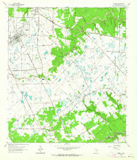
 1967 Humble1967 Print · USGSNorthern Harris County is caught in a moment of rapid suburban and industrial expansion in the late sixties. Researchers can trace family sites at Rosewood Park Cem or locate the early footprints of Houston Intercontinental Airport and Douglas MacArthur High Sch.2 unique versions available
 - 1967 Map of Harmaston
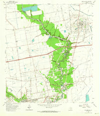
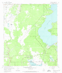 1967 Harmaston1967 Print · USGSNortheast Harris County in the late sixties shows the balance between oil production and the new reservoirs serving the Houston metro area. Genealogists and historians can trace the Missouri Pacific corridor through Harmaston, find the Jacinto Cem, or locate the Riverside Oil Field.2 unique versions available
 - 1967 Map of Aldine
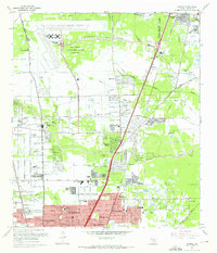
 1967 Aldine1967 Print · USGSNorth Harris County was entering a period of rapid development in the 1960s, balancing its petroleum roots with new residential neighborhoods. Genealogists and local historians can trace family sites like Paradise Cem, the Veterans Administration Cemetery, and old schools including Caroll Sch.3 unique versions available
 - 1967 Map of Highlands, 1969 Print
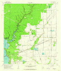
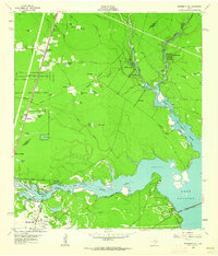
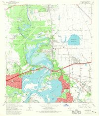 1967 Highlands1969 Print · USGSIn the late sixties, the confluence of the San Jacinto River and Buffalo Bayou served as both a heavy industrial hub and a site of state memory. Genealogists can trace family footprints in Lynchburg or McNair, while finding landmarks like the Battleship Texas and the Gospel Herald Ch.
 - 1967 Map of Crosby, 1969 Print
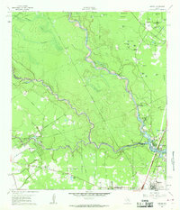
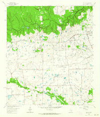
 1967 Crosby1969 Print · USGSCoastal prairie and river bottomlands meet in late-1960s Harris County as the communities of Crosby and Barrett expand. Genealogists can locate family landmarks like Bohemian Hall, Evergreen Cem, and the Sacred Heart Sch along the Southern Pacific line.
 - 1967 Map of Park Place, 1969 Print
 1967 Park Place1969 Print · USGSSoutheast Houston in the late sixties is captured here as a major hub of aviation, industry, and higher education. Genealogists and historians can trace the growth of Park Place, locate Jackson Cem, and explore the campuses of the University of Houston and Texas Southern University.
 - 1967 Map of Houston Heights, 1970 Print
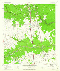
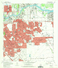
 1967 Houston Heights1970 Print · USGSNorthwest Houston expanded rapidly during the late sixties as residential neighborhoods integrated with established rail lines. Genealogists can trace family roots through numerous sites like Hollywood Cem, Booker T Washington High Sch, and Highland Heights.
 - 1967 Map of Pasadena, 1970 Print
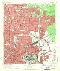
 1967 Pasadena1970 Print · USGSSoutheast of Houston in the late sixties, this area shows a dense industrial and suburban landscape emerging along the Houston Ship Channel. Genealogists and local historians can locate established schools like Pearl Hall Sch and landmarks like the Texas Chiropractic College or the crossroads at Genoa.
 - 1967 Map of Settegast, 1970 Print
 1967 Settegast1970 Print · USGSNortheast Houston's rail-and-bayou landscape is captured here during a period of significant mid-century growth. Researchers can trace historic neighborhood boundaries in Settegast and Sherwood Place or locate family sites at Oak Park Cem and Hollywood Cemetery.2 unique versions available
 - 1967 Map of La Porte, 1970 Print
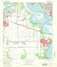 1967 La Porte1970 Print · USGSCoastal Harris County in the late sixties shows a landscape where industrial shipping channels meet growing bayfront communities. Genealogists and local historians can trace residential patterns in Lomax, locate Betheny Cem, and see the early footprint of San Jacinto College.
 - 1967 Map of Jacinto City, 1970 Print
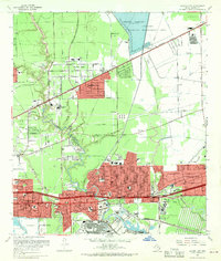 1967 Jacinto City1970 Print · USGSEastern Harris County was a landscape of rapid industrial and suburban growth in the late sixties. Researchers can trace the development of Channelview and Jacinto City while locating local landmarks like the Harris County Cem and Sheldon Fish Hatchery.
End of results
Showing maps 1-25 of 25
Top cities of Harris County
- Houston historical maps
- Pasadena historical maps
- Cypress historical maps
- Atascocita historical maps
- Baytown historical maps
- Spring historical maps
See more
Frequently asked questions
- What are the different types of historical maps available for Harris County?
- What is the oldest map of Harris County?
- Where can I purchase historical maps of Harris County for my home or office?
- Where can I download high-res historical maps of Harris County?
- Are there historical topographic maps available for Harris County?
- Is there historical aerial imagery available for Harris County?
- Where are historical maps of Harris County sourced from?