1950s Maps of Harris County, Texas
Explore 28 historic maps of Harris County from the 1950s. These maps offer a rare glimpse into what life looked like during the 1950s — showing old roads, neighborhoods, homes, and landmarks that have changed or disappeared over time.
Whether you're researching your family's past, planning a metal detecting trip, or studying how Harris County's landscape evolved across the 1950s, these high-resolution maps are a powerful tool for exploring the history of this region.
- Focus on a specific era: All maps on this page are from the 1950s, giving you a focused view of this time period.
- See what’s changed: Compare century-old streets, trails, and buildings to today's modern landscape using overlays and satellite layers.
- Research with precision: Use these maps for genealogy, historical research, land use analysis, or educational projects.
- View, download, or print: Maps are fully viewable online in high resolution, and can be downloaded or printed for your own records.
Start exploring Harris County's history through authentic maps from the 1950s. This is your window into the past.
Harris County, TX maps
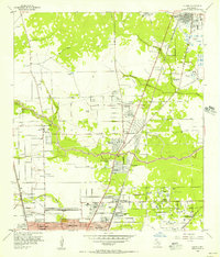
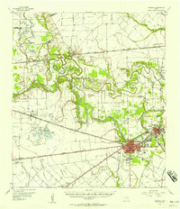
(28)- 1950 Map of Houston, 1953 Print
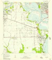
 1950 Houston1953 Print · USGSCoastal Texas in the early fifties reveals a landscape of massive civil engineering and industrial transit. Genealogists and researchers can trace the growth of the Houston suburbs and the maritime infrastructure of Galveston Bay, including the Gulf Freeway and the Texas City Dike.
 - 1954 Map of Harmaston, 1956 Print
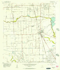
 1954 Harmaston1956 Print · USGSEastern Harris County in the mid-fifties shows the rising waters of the reservoir era alongside established rail and oil corridors. Genealogists and local historians can trace the Harrington Cem and settlements like Harmaston and Dyersdale before modern sprawl arrived.
 - 1954 Map of Humble, 1956 Print
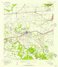
 1954 Humble1956 Print · USGSNortheast of Houston during the mid-fifties, this area shows the transition from oil fields to burgeoning suburbs. Genealogists and historians can locate family-named landmarks and institutions like Rosewood Park Cemetery, Bordersville, and the Aldine Sch.
 - 1954 Map of Crosby, 1956 Print
 1954 Crosby1956 Print · USGSCoastal Harris County in the mid-fifties is characterized here by its booming oil fields and crossroads settlements. Genealogists and local historians can trace family roots through Crosby and Barrett, or locate early landmarks like Bohemian Hall and Sacred Heart Cem.
 - 1954 Map of Aldine, 1956 Print
 1954 Aldine1956 Print · USGSNorth of Houston in the mid-fifties, this area shows a landscape of bayous and oil wells transitioning toward suburban life. Researchers can locate early landmarks like Gulf Coast Airport, St Peters Ch, and schools such as Inez Carroll Grade Sch.
 - 1954 Map of Beaumont, 1964 Print
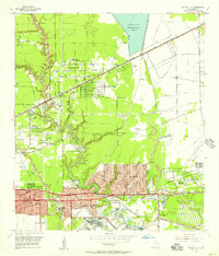
 1954 Beaumont1964 Print · USGSSoutheast Texas in the mid-fifties reveals a landscape of massive national forests, emerging reservoirs, and a booming oil economy. Genealogists and researchers can trace rural settlements like Dallardsville and Village Mills or locate early drilling sites at Sour Lake Oil Field.3 unique versions available
 - 1955 Map of Highlands, 1956 Print
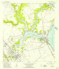
 1955 Highlands1956 Print · USGSCoastal Harris County is seen here in the mid-fifties, dominated by industrial military sites and Texas revolutionary landmarks. Trace family roots at De Zavala Cem or locate the Battleship Texas and Lynchburg Ferry Landing near the river.
 - 1955 Map of Friendswood, 1957 Print
 1955 Friendswood1957 Print · USGSSoutheastern Texas in the mid-fifties reveals an landscape of emerging aviation and oil production. Trace family landmarks and industrial roots at Ellington Air Force Base, the Friendswood Oil Field, and Whitcomb Cem.3 unique versions available
 - 1955 Map of Park Place, 1957 Print
 1955 Park Place1957 Print · USGSSoutheast Houston expanded rapidly during the mid-fifties as shipping and aviation infrastructure matured. Researchers can trace the development of neighborhood hubs like Park Place, the sprawling Houston International Airport, and dozens of local schools including Yates High Sch.
 - 1955 Map of Pearland, 1957 Print
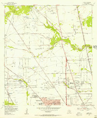
 1955 Pearland1957 Print · USGSThe mid-century Texas coastal plain near Pearland reveals a landscape of developing suburbs and active petroleum drilling. Trace the growth of Skyscraper Shadows, locate family sites at Dagg Cem, or study the industrial footprint of the Manvel Field.2 unique versions available
 - 1955 Map of League City, 1957 Print
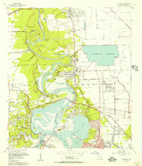
 1955 League City1957 Print · USGSCoastal Texas near the mid-fifties reveals a landscape of tidal bayous and emerging industry. Trace the early layouts of League City and Seabrook, and locate features like the Fairview Cem, Clear Lake Oil Field, and the Harris County Boys Sch.3 unique versions available
 - 1955 Map of Addicks, 1957 Print
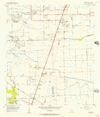
 1955 Addicks1957 Print · USGSHarris County undergoes rapid transformation in the mid-fifties as Houston's city boundary pushes west. Trace family history and early industry through the Satsuma Oil Field, Addicks Dam, and Roeder Cem.
 - 1955 Map of Almeda, 1957 Print
 1955 Almeda1957 Print · USGSIn the mid-fifties, this portion of the Texas coastal plain was a mix of prison farms, oil fields, and rural settlements. Genealogists can locate family names and burial sites at Beth Jacob Cem or Arcola-Fresno Cem and trace the old Missouri Pacific rail corridor.3 unique versions available
 - 1955 Map of Houston Heights, 1957 Print
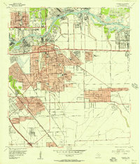
 1955 Houston Heights1957 Print · USGSHouston and its northern suburbs show rapid growth in the mid-fifties as residential blocks and rail yards expand along the bayous. Genealogists can locate family sites near Houston Heights, Adath Israel Cem, and Smith Sch.
 - 1955 Map of Sugar Land, 1957 Print
 1955 Sugar Land1957 Print · USGSFort Bend and Harris counties were transitioning from a plantation and prison-farm economy to a modern industrial corridor in the mid-1950s. Genealogists can trace family names at the Dewalt Cem or Riceville Ch, while researchers can map the early footprints of Sharpstown and Andrau Airpark.
 - 1955 Map of La Porte, 1957 Print
 1955 La Porte1957 Print · USGSThe Harris County coastline was undergoing rapid industrial change in the mid-fifties as the Houston Ship Channel expanded. Trace early settlement patterns at Morgan Point, local schools like De Walt Sch, and the historic Sylvan Beach waterfront.
 - 1955 Map of Jacinto City, 1957 Print
 1955 Jacinto City1957 Print · USGSEast of Houston in the mid-fifties, this area shows a landscape of rising suburbs and industrial infrastructure along Greens Bayou. Researchers can trace the development of Cloverleaf, find the Harris County Cem, and locate the sprawling San Jacinto Ordnance Depot.
 - 1955 Map of Settegast, 1957 Print
 1955 Settegast1957 Print · USGSNortheast Houston transitioned from residential pockets to a massive rail and industrial corridor during the mid-fifties. Genealogists and historians can locate dozens of neighborhood landmarks, including Settegast Yards, Settegast Sch, and Hollywood Cemetery.
 - 1955 Map of Pasadena, 1957 Print
 1955 Pasadena1957 Print · USGSSoutheast Texas industrial growth is on full display during the mid-fifties as the ship channel corridor rapidly expands. Genealogists and researchers can trace neighborhood development near Pasadena schools or find the footprint of the San Jacinto Ordnance Depot.
 - 1955 Map of Brookshire, 1957 Print
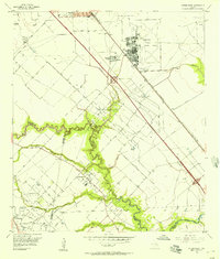
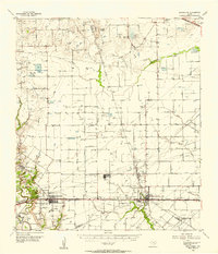 1955 Brookshire1957 Print · USGSThe growing railroad towns of Waller and Harris Counties are shown in the mid-fifties as the local energy economy takes hold. Genealogists and historians can locate family landmarks like Curry Chapel, Magnolia Cem, and the old Salt Mine at Hockley Mound.
 - 1955 Map of Richmond, 1958 Print
 1955 Richmond1958 Print · USGSFort Bend County during the mid-fifties is captured here as a landscape of meandering rivers and burgeoning rail hubs. Genealogists can trace family names through rural sites like Little Prayer Cem or follow the Old Spanish Trail through Rosenberg.
 - 1956 Map of Bacliff, 1957 Print
 1956 Bacliff1957 Print · USGSCoastal life along the western edge of the bay comes to focus in the mid-fifties, showing a network of shorebound communities and maritime routes. Genealogists can trace early neighborhood layouts in Bacliff and El Jardin Del Mar or locate landmarks like Seabrook Cem and Red Fish Island.3 unique versions available
 - 1956 Map of Algoa, 1957 Print
 1956 Algoa1957 Print · USGSThe Galveston and Brazoria county lines meet in the 1950s amidst a landscape of expanding oil fields and irrigation canals. Genealogists can trace family names near Magnolia Cem or follow the rail junction at Alvin and the smaller depot at Algoa.4 unique versions available
 - 1956 Map of Morgan Point, 1957 Print
 1956 Morgan Point1957 Print · USGSCoastal Chambers and Harris Counties are shown here during a mid-century period of industrial and suburban development. Genealogists and local historians can locate the Morgan Point Cem, trace the Southern Pacific rail lines, and explore the sprawling Goose Creek Oil Field.3 unique versions available
 - 1956 Map of Houston, 1963 Print
 1956 Houston1963 Print · USGSSoutheast Texas in the mid-fifties is captured here as a powerhouse of oil and maritime trade. Genealogists and historians can trace the foundations of Houston and its ports, alongside landmarks like the Rice Institute and the Spindletop Oil Field.2 unique versions available
Showing maps 1-25 of 28
Top cities of Harris County
- Houston historical maps
- Pasadena historical maps
- Cypress historical maps
- Atascocita historical maps
- Baytown historical maps
- Spring historical maps
See more
Frequently asked questions
- What are the different types of historical maps available for Harris County?
- What is the oldest map of Harris County?
- Where can I purchase historical maps of Harris County for my home or office?
- Where can I download high-res historical maps of Harris County?
- Are there historical topographic maps available for Harris County?
- Is there historical aerial imagery available for Harris County?
- Where are historical maps of Harris County sourced from?