1960s Maps of Wimberley, Texas
Explore 3 historic maps of Wimberley from the 1960s. These maps offer a rare glimpse into what life looked like during the 1960s — showing old roads, neighborhoods, homes, and landmarks that have changed or disappeared over time.
Whether you're researching your family's past, planning a metal detecting trip, or studying how Wimberley's landscape evolved across the 1960s, these high-resolution maps are a powerful tool for exploring the history of this region.
- Focus on a specific era: All maps on this page are from the 1960s, giving you a focused view of this time period.
- See what’s changed: Compare century-old streets, trails, and buildings to today's modern landscape using overlays and satellite layers.
- Research with precision: Use these maps for genealogy, historical research, land use analysis, or educational projects.
- View, download, or print: Maps are fully viewable online in high resolution, and can be downloaded or printed for your own records.
Start exploring Wimberley's history through authentic maps from the 1960s. This is your window into the past.
Wimberley, TX maps
(3)- 1963 Map of Devils Backbone, 1965 Print
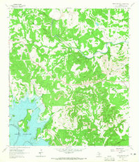 1963 Devils Backbone1965 Print · USGSThe Comal and Hays county line near the Guadalupe River is shown here in the early sixties, just as the basin began filling. Researchers can locate family landmarks like Valley Ford Cemetery, El Rancho Cima, and the ridge road along the Devils Backbone.3 unique versions available
 - 1964 Map of Driftwood, 1966 Print
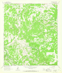 1964 Driftwood1966 Print · USGSThe hills of Hays County are captured here in the mid-1960s, showing the early character of Wimberley and the rural roads near Driftwood. Genealogists and local researchers can trace family ranch lands like Storm Ranch and landmarks like Joe Wimberley Mountain.3 unique versions available
 - 1964 Map of Wimberley, 1966 Print
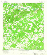 1964 Wimberley1966 Print · USGSThe Wimberley area of the Texas Hill Country comes into focus during the mid-1960s, showing a landscape defined by the Blanco River and ranching heritage. Researchers can trace family-named lands like Freeman Ranch and Scrutchin Ranch or locate the early layout of Pioneer Town.2 unique versions available
End of results
Showing maps 1-3 of 3
Top cities near Wimberley
- Austin historical maps
- New Braunfels historical maps
- San Marcos historical maps
- Kyle historical maps
- Buda historical maps
- Dripping Springs historical maps
See more
Top neighborhoods of Wimberley
Frequently asked questions
- What are the different types of historical maps available for Wimberley?
- What is the oldest map of Wimberley?
- Where can I purchase historical maps of Wimberley for my home or office?
- Where can I download high-res historical maps of Wimberley?
- Are there historical topographic maps available for Wimberley?
- Is there historical aerial imagery available for Wimberley?
- Where are historical maps of Wimberley sourced from?