1980s Maps of Wimberley, Texas
Explore 4 historic maps of Wimberley from the 1980s. These maps offer a rare glimpse into what life looked like during the 1980s — showing old roads, neighborhoods, homes, and landmarks that have changed or disappeared over time.
Whether you're researching your family's past, planning a metal detecting trip, or studying how Wimberley's landscape evolved across the 1980s, these high-resolution maps are a powerful tool for exploring the history of this region.
- Focus on a specific era: All maps on this page are from the 1980s, giving you a focused view of this time period.
- See what’s changed: Compare century-old streets, trails, and buildings to today's modern landscape using overlays and satellite layers.
- Research with precision: Use these maps for genealogy, historical research, land use analysis, or educational projects.
- View, download, or print: Maps are fully viewable online in high resolution, and can be downloaded or printed for your own records.
Start exploring Wimberley's history through authentic maps from the 1980s. This is your window into the past.
Wimberley, TX maps
(4)- 1985 Map of New Braunfels
 1985 New Braunfels1985 Print · USGSThe Texas Hill Country meets the growing San Antonio suburbs in the mid-1980s, showing a landscape of river-fed towns and military grounds. Trace family roots in historic Gruene or Boerne, and locate landmarks like Canyon Lake and Randolph Air Force Base.
 - 1985 Map of Pedernales River
 1985 Pedernales River1985 Print · USGSThe Texas Hill Country comes alive in the mid-1980s, documenting a landscape of ranching roots and presidential history. Researchers can trace historic settlements like Luckenbach, the presidential grounds of Lyndon B. Johnson National Historic Park, and the early rail path of the Southern Pacific Railroad.2 unique versions available
 - 1989 Map of Wimberley
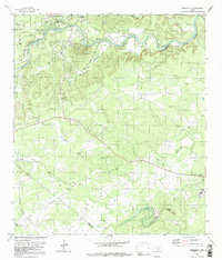 1989 Wimberley1989 Print · USGSThe Texas Hill Country around the Blanco River shows its late-twentieth-century character as the community of Wimberley expanded toward Flite Acres. Genealogists and local historians can trace family locations near Eagle Mountain, the local Cem, or along the banks of Cypress Creek.
 - 1989 Map of Devils Backbone
 1989 Devils Backbone1989 Print · USGSThe Texas Hill Country at the end of the 1980s reveals a landscape defined by the waters of the Blanco River and the expanding reach of Canyon Lake. Researchers can trace old family burial grounds at Valley Ford Cemetery and Hugo Cem or explore the heights of the Devils Backbone.
End of results
Showing maps 1-4 of 4
Top cities near Wimberley
- Austin historical maps
- New Braunfels historical maps
- San Marcos historical maps
- Kyle historical maps
- Buda historical maps
- Dripping Springs historical maps
See more
Top neighborhoods of Wimberley
Frequently asked questions
- What are the different types of historical maps available for Wimberley?
- What is the oldest map of Wimberley?
- Where can I purchase historical maps of Wimberley for my home or office?
- Where can I download high-res historical maps of Wimberley?
- Are there historical topographic maps available for Wimberley?
- Is there historical aerial imagery available for Wimberley?
- Where are historical maps of Wimberley sourced from?