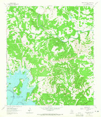
1963 Map of Devils Backbone
USGS Topo · Published 1965About this map
Canyon Reservoir dominates the southwestern corner of this 1963 survey, where the waters of the Guadalupe River meet the rising shoreline of the newly formed basin. To the north, the terrain transitions into the iconic limestone ridges of the Devils Backbone, a prominent geological feature that provides a natural corridor for regional travel. This area of central Texas reflects a landscape in transition, where established ranching land and rural landmarks like El Rancho Cima and Tower Hill coexist with the modern hydrological engineering of the reservoir system.
Find a feature on this map
33 named features on this map. Tap any name to fly to it.
Don’t see what you’re looking for? This feature index may not catch every label — zoom into the map to look around manually.
Map Details
Editions of this 1963 Devils Backbone Map
3 editions found
Other maps of this area

1887 · Blanco
USGS Topo · 1:125,000

1894 · Blanco
USGS Topo · 1:125,000

1920 · Smithsons Valley
USGS Topo · 1:62,500

1925 · Hunter No 3
USGS Topo · 1:48,000

1925 · Smithson Valley No. 1
USGS Topo · 1:48,000

1927 · Smithson Valley
USGS Topo · 1:62,500

1929 · Hunter
USGS Topo · 1:62,500

1929 · Smithson Valley
USGS Topo · 1:62,500

1940 · Smithson Valley
USGS Topo · 1:62,500

1954 · Llano
USGS Topo · 1:250,000