1940s Maps of Coffee City, Texas
Explore 3 historic maps of Coffee City from the 1940s. These maps offer a rare glimpse into what life looked like during the 1940s — showing old roads, neighborhoods, homes, and landmarks that have changed or disappeared over time.
Whether you're researching your family's past, planning a metal detecting trip, or studying how Coffee City's landscape evolved across the 1940s, these high-resolution maps are a powerful tool for exploring the history of this region.
- Focus on a specific era: All maps on this page are from the 1940s, giving you a focused view of this time period.
- See what’s changed: Compare century-old streets, trails, and buildings to today's modern landscape using overlays and satellite layers.
- Research with precision: Use these maps for genealogy, historical research, land use analysis, or educational projects.
- View, download, or print: Maps are fully viewable online in high resolution, and can be downloaded or printed for your own records.
Start exploring Coffee City's history through authentic maps from the 1940s. This is your window into the past.
Coffee City, TX maps
(3)- 1946 Map of Bullard, 1960 Print
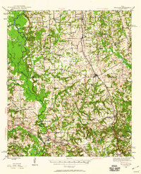 1946 Bullard1960 Print · USGSEast Texas rail and river life converge in the 1940s as the St Louis Southwestern tracks link rural farming hubs. Trace local family history through numerous landmarks like Larissa Cem, the Kickapoo Monument, and Mount Selman.2 unique versions available
 - 1948 Map of Bullard
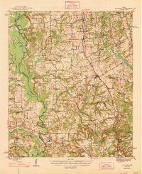 1948 Bullard1948 Print · USGSNortheastern Cherokee and southern Smith counties are captured here in the late forties, showcasing a network of rural schools and rail-fed towns. Genealogists can trace family sites at Larissa Cem, Mount Comfort Ch, and the high ground of Kickapoo Mtn.
 - 1949 Map of Frankston, 1964 Print
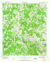 1949 Frankston1964 Print · USGSEast Texas ranching and timber country at the end of the 1940s was defined by the Southern Pacific rail line and small rural school districts. Researchers can find many family landmarks, from Moores Station and Fincastle to the Lapoynor Sch and Alligator Cem.3 unique versions available
End of results
Showing maps 1-3 of 3
Top cities near Coffee City
- Tyler historical maps
- Jacksonville historical maps
- Athens historical maps
- Chandler historical maps
- Bullard historical maps
- Frankston historical maps
See more
Frequently asked questions
- What are the different types of historical maps available for Coffee City?
- What is the oldest map of Coffee City?
- Where can I purchase historical maps of Coffee City for my home or office?
- Where can I download high-res historical maps of Coffee City?
- Are there historical topographic maps available for Coffee City?
- Is there historical aerial imagery available for Coffee City?
- Where are historical maps of Coffee City sourced from?