1970s Maps of Coffee City, Texas
Explore 2 historic maps of Coffee City from the 1970s. These maps offer a rare glimpse into what life looked like during the 1970s — showing old roads, neighborhoods, homes, and landmarks that have changed or disappeared over time.
Whether you're researching your family's past, planning a metal detecting trip, or studying how Coffee City's landscape evolved across the 1970s, these high-resolution maps are a powerful tool for exploring the history of this region.
- Focus on a specific era: All maps on this page are from the 1970s, giving you a focused view of this time period.
- See what’s changed: Compare century-old streets, trails, and buildings to today's modern landscape using overlays and satellite layers.
- Research with precision: Use these maps for genealogy, historical research, land use analysis, or educational projects.
- View, download, or print: Maps are fully viewable online in high resolution, and can be downloaded or printed for your own records.
Start exploring Coffee City's history through authentic maps from the 1970s. This is your window into the past.
Coffee City, TX maps
(2)- 1973 Map of Berryville, 1976 Print
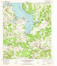 1973 Berryville1976 Print · USGSLake Palestine and the Neches River valley define this East Texas landscape in the early seventies as new shorelines met established rail towns. Genealogists can trace family names through Kickapoo Cem, Wafford Cem, and the Kickapoo Battlefield Monument.2 unique versions available
 - 1973 Map of Saline Bay, 1976 Print
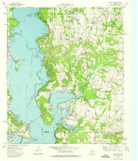 1973 Saline Bay1976 Print · USGSThe East Texas lakefront was rapidly evolving in the early seventies as Lake Palestine submerged the old Neches River valley. Researchers can trace the development of Coffee City or locate rural sites like Bethlehem Church and Loffin Cemetery.3 unique versions available
End of results
Showing maps 1-2 of 2
Top cities near Coffee City
- Tyler historical maps
- Jacksonville historical maps
- Athens historical maps
- Chandler historical maps
- Bullard historical maps
- Frankston historical maps
See more
Frequently asked questions
- What are the different types of historical maps available for Coffee City?
- What is the oldest map of Coffee City?
- Where can I purchase historical maps of Coffee City for my home or office?
- Where can I download high-res historical maps of Coffee City?
- Are there historical topographic maps available for Coffee City?
- Is there historical aerial imagery available for Coffee City?
- Where are historical maps of Coffee City sourced from?