1970s Maps of Howard County, Texas
Explore 11 historic maps of Howard County from the 1970s. These maps offer a rare glimpse into what life looked like during the 1970s — showing old roads, neighborhoods, homes, and landmarks that have changed or disappeared over time.
Whether you're researching your family's past, planning a metal detecting trip, or studying how Howard County's landscape evolved across the 1970s, these high-resolution maps are a powerful tool for exploring the history of this region.
- Focus on a specific era: All maps on this page are from the 1970s, giving you a focused view of this time period.
- See what’s changed: Compare century-old streets, trails, and buildings to today's modern landscape using overlays and satellite layers.
- Research with precision: Use these maps for genealogy, historical research, land use analysis, or educational projects.
- View, download, or print: Maps are fully viewable online in high resolution, and can be downloaded or printed for your own records.
Start exploring Howard County's history through authentic maps from the 1970s. This is your window into the past.
Howard County, TX maps
(11)- 1970 Map of Vealmoor, 1973 Print
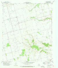
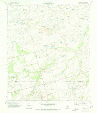 1970 Vealmoor1973 Print · USGSVealmoor sat at the heart of the Permian Basin's oil country in the 1970s, where Borden and Howard counties meet. Genealogists and researchers can trace local family landmarks and industrial sites from Vealmoor Cem to the sprawling Jo Mill Oil Field and the distinctive Outlaw Road.
 - 1970 Map of Ackerly, 1973 Print
 1970 Ackerly1973 Print · USGSAckerly and the surrounding High Plains are captured here in the early seventies, at the intersection of four Texas counties. Researchers can trace the layout of the Sands Sch, locate the Fairhaven Cem, and see the extent of the local Oil Field.
 - 1970 Map of Gunsight Draw, 1973 Print
 1970 Gunsight Draw1973 Print · USGSThis West Texas landscape at the start of the 1970s shows the ranching and energy infrastructure straddling the Borden and Howard County line. Researchers can trace land use through numerous named stock tanks like Bombsight Tank and the prominence of West Gunsight Mtn.
 - 1970 Map of Gunsight Draw SE, 1974 Print
 1970 Gunsight Draw SE1974 Print · USGSBorden and Howard Counties were defined by the intersection of the petroleum industry and cattle ranching in the early 1970s. Trace the growth of the Hobo Oil Field and Vincent Oil Field or locate rural landmarks like Fairview Cem and Cedar Point.
 - 1971 Map of Luther, 1973 Print
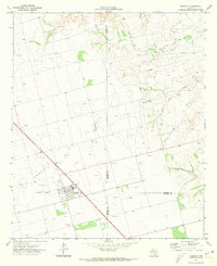
 1971 Luther1973 Print · USGSHoward County in the early seventies is a landscape shaped by petroleum and water management. Genealogists and historians can trace the rural community at Luther, the Gay Hill Sch, and the winding banks of Wildhorse Creek.
 - 1971 Map of Lees, 1973 Print
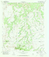
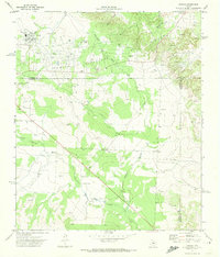
 1971 Lees1973 Print · USGSGlasscock County at the start of the 1970s reveals a West Texas landscape shaped by petroleum and ranching. You can trace the community around Lees, the industrial footprint of the northern Oil Field, and rural landmarks like the North Cauble Windmill.
 - 1971 Map of Moss Creek Lake, 1974 Print
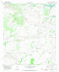
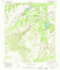 1971 Moss Creek Lake1974 Print · USGSThe High Plains of Howard County are shown here in the early 1970s, at a time when oil production and water management shaped the local landscape. Researchers can locate the Howard Glasscock Oil Field, the community of Otis Chalk, and landmarks like Signal Peak.
 - 1971 Map of Forsan, 1974 Print
 1971 Forsan1974 Print · USGSSettled along the Howard and Glasscock county lines in the early 1970s, this area shows a landscape defined by the North Concho River. Researchers can trace the local infrastructure of Forsan and Ross City, locating the High Sch and Cem.
 - 1971 Map of Big Spring South, 1974 Print
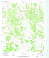
 1971 Big Spring South1974 Print · USGSBig Spring and its surrounding oil fields are captured here in the early seventies, detailing the town's expansion across the West Texas plains. Researchers can locate several local schools like Marcy Sch or trace family plots at Trinity Memorial Park (Cem).2 unique versions available
 - 1971 Map of Coahoma, 1974 Print
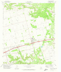 1971 Coahoma1974 Print · USGSThis West Texas region comes into focus in the early 1970s, showcasing the intersection of the petroleum industry and rural life. Researchers can trace the layout of Coahoma and find local landmarks like the Salem Ch, Sand Springs, and the Rodeo Ground.
 - 1971 Map of Big Spring North, 1974 Print
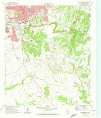
 1971 Big Spring North1974 Print · USGSHoward County's rail and ranching landscape comes alive in the late thirties, centered on the growing industrial hub of Big Spring. Genealogists can trace family footprints through rural districts like Luther and Sand Springs, or locate old landmarks like Bethel Ch and the Richland Sch.
End of results
Showing maps 1-11 of 11
Top cities of Howard County
Frequently asked questions
- What are the different types of historical maps available for Howard County?
- What is the oldest map of Howard County?
- Where can I purchase historical maps of Howard County for my home or office?
- Where can I download high-res historical maps of Howard County?
- Are there historical topographic maps available for Howard County?
- Is there historical aerial imagery available for Howard County?
- Where are historical maps of Howard County sourced from?