1950s Maps of Howard County, Texas
Explore 8 historic maps of Howard County from the 1950s. These maps offer a rare glimpse into what life looked like during the 1950s — showing old roads, neighborhoods, homes, and landmarks that have changed or disappeared over time.
Whether you're researching your family's past, planning a metal detecting trip, or studying how Howard County's landscape evolved across the 1950s, these high-resolution maps are a powerful tool for exploring the history of this region.
- Focus on a specific era: All maps on this page are from the 1950s, giving you a focused view of this time period.
- See what’s changed: Compare century-old streets, trails, and buildings to today's modern landscape using overlays and satellite layers.
- Research with precision: Use these maps for genealogy, historical research, land use analysis, or educational projects.
- View, download, or print: Maps are fully viewable online in high resolution, and can be downloaded or printed for your own records.
Start exploring Howard County's history through authentic maps from the 1950s. This is your window into the past.
Howard County, TX maps
(8)- 1951 Map of Ira SW
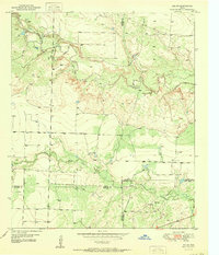 1951 Ira SW1951 Print · USGSTexas ranching and early petroleum development meet in the early 1950s where four counties converge. Trace the landscape of the Conrad Ranch, find the Colorado River, and locate industrial markers like the Oil Well and Oil Tanks.2 unique versions available
 - 1951 Map of Vincent, 1953 Print
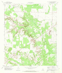
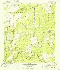 1951 Vincent1953 Print · USGSThe ranching and oil country of Howard and Mitchell Counties is captured here in the early fifties. Genealogists and local historians can locate Vincent and the Vincent Cem, or trace the path of Morgan Creek past various windmills and early oil wells.2 unique versions available
 - 1951 Map of Iatan, 1979 Print
 1951 Iatan1979 Print · USGSMid-century Howard County shows a landscape defined by the arrival of the railroad and the growth of the oil industry. Genealogists and historians can trace the Iatan Cem, the settlement of Iatan, and industrial features like the Tank Farm and Rattlesnake Gap.
 - 1952 Map of Iatan
 1952 Iatan1952 Print · USGSHoward County's petroleum and ranching landscape is captured here in the early fifties, as the oil industry expanded across the West Texas plains. Researchers can trace the mid-century infrastructure of the East Field, the Iatan Cem, and the path of the Texas and Pacific railroad.
 - 1954 Map of Big Spring, 1965 Print
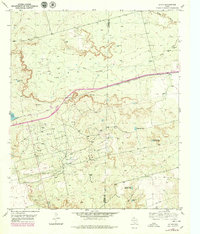
 1954 Big Spring1965 Print · USGSWest Texas in the mid-1950s shows a landscape of growing oil towns and vital rail links along the Texas and Pacific RR. Researchers can trace the development of Big Spring, find smaller settlements like Knott and Lomax, or locate landmarks such as Boyds Chapel and Signal Mountain.4 unique versions available
 - 1954 Map of Big Spring North, 1976 Print
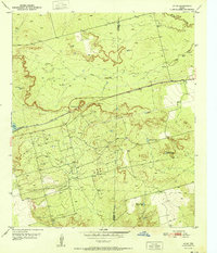
 1954 Big Spring North1976 Print · USGSBig Spring and the surrounding Howard County plains are captured here in the 1970s as the local oil and transport economy flourished. Genealogists and historians can trace the Missouri Pacific rail corridor past Mount Olive Cemetery and the Refinery.
 - 1954 Map of Big Spring North NE, 1984 Print
 1954 Big Spring North NE1984 Print · USGSThe West Texas petroleum landscape of the early seventies is meticulously documented here, showing the infrastructure of the East Vealmoor Oil Field. Researchers can trace industrial landmarks like the Refinery and Morgan Creek Pumping Sta.
 - 1958 Map of Big Spring
 1958 Big Spring1958 Print · USGSThe West Texas oil boom was in full swing during the late fifties, transforming the landscape around Howard and Mitchell counties. Genealogists and historians can trace the growth of Big Spring and Snyder alongside industrial landmarks like the Kelly-Snyder Oil Field and the Santa Fe rail lines.
End of results
Showing maps 1-8 of 8
Top cities of Howard County
Frequently asked questions
- What are the different types of historical maps available for Howard County?
- What is the oldest map of Howard County?
- Where can I purchase historical maps of Howard County for my home or office?
- Where can I download high-res historical maps of Howard County?
- Are there historical topographic maps available for Howard County?
- Is there historical aerial imagery available for Howard County?
- Where are historical maps of Howard County sourced from?