
1951 Map of Ira SW
USGS Topo · Published 1951About this map
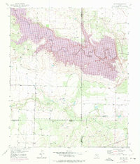
The Colorado River carves a deep path across the northern half of this landscape, its winding course marked by dramatic elevation changes. In the early 1950s, this area of West Texas shows the quiet intersection of ranching and the emerging petroleum industry, with the Conrad Ranch situated near the center of the sheet. The terrain is defined by the drainage of Willow Creek, which flows southeast across a boundary where four counties—Borden, Howard, Scurry, and Mitchell—meet in close proximity. Economic activity is concentrated around industrial markers like the Oil Well, Oil Tanks, and a prominent Pipe Line that cuts across the northern ridges. For genealogists and local historians, the map offers a precise look at mid-century land use, from isolated water sources like a Windmill to the specific placements of ranch buildings before later decades of development changed the footprint of these rural holdings.
Find a feature on this map
11 named features on this map. Tap any name to fly to it.
Don’t see what you’re looking for? This feature index may not catch every label — zoom into the map to look around manually.
Map Details
Editions of this 1951 Ira SW Map
2 editions found
Other maps of this area

1942 · Big Spring North
USGS Topo · 1:62,500

1951 · Ira
USGS Topo · 1:24,000

1951 · Ira NW
USGS Topo · 1:24,000

1951 · Vincent
USGS Topo · 1:24,000

1952 · Cuthbert
USGS Topo · 1:24,000

1952 · Ira NE
USGS Topo · 1:24,000

1954 · Big Spring
USGS Topo · 1:250,000

1954 · Big Spring North NE
USGS Topo · 1:24,000

1958 · Big Spring
USGS Topo · 1:250,000
1970 · Gunsight Draw NE
USGS Topo · 1:24,000