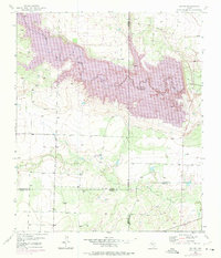
1951 Map of Ira SW
USGS Topo · Published 1975About this map
Lake J B Thomas dominates the landscape of this West Texas quadrangle, where the Colorado River was dammed to provide a vital water source for the surrounding high plains. The map illustrates a stark intersection of energy production and cattle ranching, with the Reinecke Oil Field and Vincent Oil Field sprawling across the western terrain alongside individual Oil Wells. Local land use is further anchored by sites like the Conrad Ranch and the presence of numerous Windmills across the basin of Willow Creek. This 1951 record, updated in the 1970s, captures the region at a period of intense industrial activity, marking the intricate boundary lines where Scurry, Borden, Howard, and Mitchell counties meet.
Find a feature on this map
14 named features on this map. Tap any name to fly to it.
Don’t see what you’re looking for? This feature index may not catch every label — zoom into the map to look around manually.
Map Details
Editions of this 1951 Ira SW Map
2 editions found
Other maps of this area

1942 · Big Spring North
USGS Topo · 1:62,500

1951 · Ira SW
USGS Topo · 1:24,000

1951 · Ira
USGS Topo · 1:24,000

1951 · Ira NW
USGS Topo · 1:24,000

1951 · Vincent
USGS Topo · 1:24,000

1952 · Cuthbert
USGS Topo · 1:24,000

1952 · Ira NE
USGS Topo · 1:24,000

1954 · Big Spring
USGS Topo · 1:250,000

1954 · Big Spring North NE
USGS Topo · 1:24,000

1958 · Big Spring
USGS Topo · 1:250,000