
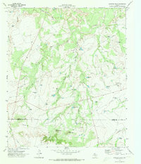
1954 Map of Big Spring North NE
USGS Topo · Published 1984About this map
The East Vealmoor Oil Field anchors the northern landscape of this Howard County quadrangle, where the industrial footprint of petroleum extraction meets the drainage basins of West Texas. This era of resource development is clearly marked by a dense network of Pipelines and a specialized Morgan Creek Pumping Sta that supported regional energy infrastructure. The terrain is defined by the contrasting elevations of Flat Top Mountain and the carved paths of Morgan Creek and Wildhorse Creek. Along the northern edge, a Refinery and numerous Gravel Pit sites indicate an active economy built on extraction and processing. Significant water engineering is also visible through the presence of a large Aqueduct, illustrating the vital importance of water management in this arid stretch of the state during the early 1970s field checking period.
Find a feature on this map
14 named features on this map. Tap any name to fly to it.
Don’t see what you’re looking for? This feature index may not catch every label — zoom into the map to look around manually.
Map Details
Editions of this 1954 Big Spring North NE Map
This is the sole edition of this map. No revisions or reprints were ever made.
Other maps of this area

1942 · Big Spring North
USGS Topo · 1:62,500

1951 · Ira SW
USGS Topo · 1:24,000

1951 · Vincent
USGS Topo · 1:24,000

1951 · Iatan
USGS Topo · 1:24,000

1952 · Iatan
USGS Topo · 1:24,000

1954 · Big Spring
USGS Topo · 1:250,000

1954 · Big Spring North
USGS Topo · 1:24,000

1958 · Big Spring
USGS Topo · 1:250,000

1965 · Big Spring North
USGS Topo · 1:24,000
1970 · Gunsight Draw
USGS Topo · 1:24,000