1900s (20th Century) Maps of Anson, Texas
Explore 6 historic maps of Anson from the 1900s (20th Century). These maps offer a rare glimpse into what life looked like during the 1900s — showing old roads, neighborhoods, homes, and landmarks that have changed or disappeared over time.
Whether you're researching your family's past, planning a metal detecting trip, or studying how Anson's landscape evolved across the 1900s, these high-resolution maps are a powerful tool for exploring the history of this region.
- Focus on a specific era: All maps on this page are from the 1900s, giving you a focused view of this time period.
- See what’s changed: Compare century-old streets, trails, and buildings to today's modern landscape using overlays and satellite layers.
- Research with precision: Use these maps for genealogy, historical research, land use analysis, or educational projects.
- View, download, or print: Maps are fully viewable online in high resolution, and can be downloaded or printed for your own records.
Start exploring Anson's history through authentic maps from the 1900s. This is your window into the past.
Anson, TX maps
(6)- 1954 Map of Abilene, 1966 Print
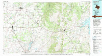
 1954 Abilene1966 Print · USGSThe Texas Big Country comes into focus in the mid-1950s as petroleum and new water projects reshape the landscape. Local historians can trace the Butterfield Trail, find the Fort Phantom Hill Ruins, and locate numerous small communities along the Texas & Pacific line.2 unique versions available
 - 1957 Map of Hawley, 1958 Print
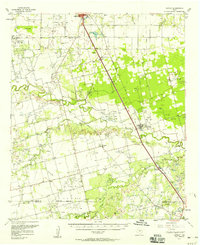 1957 Hawley1958 Print · USGSJones and Taylor Counties are captured in the late fifties during a period of significant petroleum expansion and rural settlement. Genealogists and historians can trace family roots at Hawley, Anson, and the Cosden Refinery, or locate old landmarks like the Hodges Sch.
 - 1958 Map of Abilene
 1958 Abilene1958 Print · USGSMid-century West Texas comes alive in this survey of the Abilene and Stephenville region during a period of steady oil expansion and military growth. Genealogists and local historians can trace the paths of the Texas & Pacific RR through historic towns, locate the Fort Griffin Ruins, and find smaller settlements like Desdemona and Lueders.
 - 1965 Map of Anson, 1967 Print
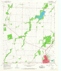 1965 Anson1967 Print · USGSJones County's plains are captured in the mid-sixties, centered on the growing town of Anson. Genealogists and historians can trace community landmarks like Anderson Chapel Cem, Hanna Ch, and the outlying settlement of Radium.
 - 1984 Map of Truby
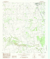 1984 Truby1984 Print · USGSJones County ranching country and river bottoms are captured here in the early eighties. Genealogists and local historians can trace the course of the Clear Fork Brazos River past the settlement of Truby and the outskirts of Anson.
 - 1985 Map of Stamford, 1992 Print
 1985 Stamford1992 Print · USGSMid-century West Texas comes alive in this survey of the Brazos River country, showing a landscape defined by oil production and rail transport. Researchers can locate family landmarks like the Avoca Sch, New Hope Ch, and the frontier history at Fort Griffin State Park.
End of results
Showing maps 1-6 of 6
Top cities near Anson
Frequently asked questions
- What are the different types of historical maps available for Anson?
- What is the oldest map of Anson?
- Where can I purchase historical maps of Anson for my home or office?
- Where can I download high-res historical maps of Anson?
- Are there historical topographic maps available for Anson?
- Is there historical aerial imagery available for Anson?
- Where are historical maps of Anson sourced from?