1920s Maps of Karnes County, Texas
Explore 2 historic maps of Karnes County from the 1920s. These maps offer a rare glimpse into what life looked like during the 1920s — showing old roads, neighborhoods, homes, and landmarks that have changed or disappeared over time.
Whether you're researching your family's past, planning a metal detecting trip, or studying how Karnes County's landscape evolved across the 1920s, these high-resolution maps are a powerful tool for exploring the history of this region.
- Focus on a specific era: All maps on this page are from the 1920s, giving you a focused view of this time period.
- See what’s changed: Compare century-old streets, trails, and buildings to today's modern landscape using overlays and satellite layers.
- Research with precision: Use these maps for genealogy, historical research, land use analysis, or educational projects.
- View, download, or print: Maps are fully viewable online in high resolution, and can be downloaded or printed for your own records.
Start exploring Karnes County's history through authentic maps from the 1920s. This is your window into the past.
Karnes County, TX maps
(2)- 1920 Map of Smiley
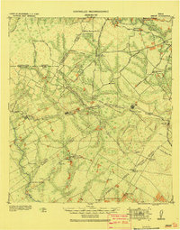 1920 Smiley1920 Print · USGSSouth Texas ranching and rail life are preserved here in the era following the first World War. Genealogists can trace family roots through labeled landmarks like Willow Springs Ranch, the Southern Pacific Railroad, and the settlement at Nixon.
 - 1925 Map of Tordia No. 1
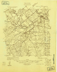 1925 Tordia No. 11925 Print · USGSKarnes and Wilson Counties are documented here in the mid-1920s as rural agriculture and rail lines shaped the river valley. Genealogists can trace family landmarks and local education hubs like Deweeville, Froshinn Hall, and the Three Oaks School.
End of results
Showing maps 1-2 of 2
Top cities of Karnes County
Frequently asked questions
- What are the different types of historical maps available for Karnes County?
- What is the oldest map of Karnes County?
- Where can I purchase historical maps of Karnes County for my home or office?
- Where can I download high-res historical maps of Karnes County?
- Are there historical topographic maps available for Karnes County?
- Is there historical aerial imagery available for Karnes County?
- Where are historical maps of Karnes County sourced from?