1950s Maps of Karnes County, Texas
Explore 11 historic maps of Karnes County from the 1950s. These maps offer a rare glimpse into what life looked like during the 1950s — showing old roads, neighborhoods, homes, and landmarks that have changed or disappeared over time.
Whether you're researching your family's past, planning a metal detecting trip, or studying how Karnes County's landscape evolved across the 1950s, these high-resolution maps are a powerful tool for exploring the history of this region.
- Focus on a specific era: All maps on this page are from the 1950s, giving you a focused view of this time period.
- See what’s changed: Compare century-old streets, trails, and buildings to today's modern landscape using overlays and satellite layers.
- Research with precision: Use these maps for genealogy, historical research, land use analysis, or educational projects.
- View, download, or print: Maps are fully viewable online in high resolution, and can be downloaded or printed for your own records.
Start exploring Karnes County's history through authentic maps from the 1950s. This is your window into the past.
Karnes County, TX maps
(11)- 1953 Map of Crystal City
 1953 Crystal City1953 Print · USGSSouth Texas in the early fifties was a landscape of expanding oil fields and vital rail connections. Genealogists and researchers can trace family lands along the Nueces River or locate heritage sites in Asherton, Big Wells, and Batesville.
 - 1953 Map of Beeville
 1953 Beeville1953 Print · USGSThe Texas Coastal Bend in the early fifties shows a landscape of growing regional hubs and vital maritime corridors. Trace the rail-and-river economy through Goliad, locate the Matagorda Lighthouse, and explore the sprawling Aransas National Wildlife Refuge.
 - 1953 Map of Seguin, 1965 Print
 1953 Seguin1965 Print · USGSSouth Texas in the early fifties shows a thriving river-and-rail economy across the Guadalupe and Colorado basins. Genealogists and historians can trace rail routes like the Southern Pacific through Seguin, locate oil wells, or find the Gary AAF near San Marcos.4 unique versions available
 - 1954 Map of San Antonio, 1964 Print
 1954 San Antonio1964 Print · USGSSan Antonio and the Texas Hill Country are captured here in the mid-fifties, showing a landscape defined by massive military air bases and the rising Canyon Reservoir. Trace family ties through historic rail towns like D'Hanis and Castroville or explore the Cold War footprint of Lackland AFB and Randolph AFB.3 unique versions available
 - 1955 Map of Crystal City, 1976 Print
 1955 Crystal City1976 Print · USGSSouth Texas ranching and oil country come into focus in the mid-fifties as the rail lines and rivers connect growing hubs. Researchers can trace the development of energy fields like Washburn Oil Field or locate historic settlements from Asherton to Three Rivers.
 - 1956 Map of Suniland
 1956 Suniland1956 Print · USGSLive Oak County ranching culture and rural infrastructure are captured here in the mid-fifties, just as the region’s landscape was maturing. Genealogists can trace family legacies through properties like the Poe Ranch and find defunct community hubs like North School and the Whitsett Pump Station.
 - 1956 Map of Beeville
 1956 Beeville1956 Print · USGSCoastal Texas and the brush country interior are shown in the mid-fifties, from the coastal bays to the inland oil fields. Trace the old rail lines of the Southern Pacific RR or locate the historic Matagorda Lighthouse and the Aransas National Wildlife Refuge.2 unique versions available
 - 1956 Map of Pettus
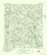 1956 Pettus1956 Print · USGSBee and Karnes counties are shown during the mid-century oil boom, when petroleum production and rail transport defined the landscape. Researchers can trace family homesteads and vanished schools such as Richland School, the North Pettus Oil Field, and the Salt Branch Church.
 - 1956 Map of Karnes City
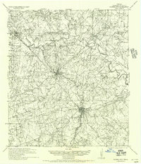 1956 Karnes City1956 Print · USGSKarnes County in the mid-twentieth century was a landscape of river-bottom farms and segregated rural schools. Genealogists can trace family holdings like the Salge Ranch and Pollock Farm or locate vanished sites like Bridger School (Colored) and Germania Hall.
 - 1957 Map of San Antonio
 1957 San Antonio1957 Print · USGSSan Antonio and the Texas Hill Country are shown here during the mid-fifties, capturing the region's expanding post-war military and transportation footprint. Genealogists and local historians can trace the early residential boundaries of Alamo Heights or locate rural landmarks like St Hedwig and Medina Lake.
 - 1958 Map of Seguin
 1958 Seguin1958 Print · USGSSouth Texas in the late fifties was a network of river-valley settlements and active oilfields tied together by major rail lines. Genealogists and historians can trace family-named sites across Rabb Prairie, locate the Behring Store, or follow the Southern Pacific through Schulenburg.
End of results
Showing maps 1-11 of 11
Top cities of Karnes County
Frequently asked questions
- What are the different types of historical maps available for Karnes County?
- What is the oldest map of Karnes County?
- Where can I purchase historical maps of Karnes County for my home or office?
- Where can I download high-res historical maps of Karnes County?
- Are there historical topographic maps available for Karnes County?
- Is there historical aerial imagery available for Karnes County?
- Where are historical maps of Karnes County sourced from?