1920s Maps of La Salle County, Texas
Explore 2 historic maps of La Salle County from the 1920s. These maps offer a rare glimpse into what life looked like during the 1920s — showing old roads, neighborhoods, homes, and landmarks that have changed or disappeared over time.
Whether you're researching your family's past, planning a metal detecting trip, or studying how La Salle County's landscape evolved across the 1920s, these high-resolution maps are a powerful tool for exploring the history of this region.
- Focus on a specific era: All maps on this page are from the 1920s, giving you a focused view of this time period.
- See what’s changed: Compare century-old streets, trails, and buildings to today's modern landscape using overlays and satellite layers.
- Research with precision: Use these maps for genealogy, historical research, land use analysis, or educational projects.
- View, download, or print: Maps are fully viewable online in high resolution, and can be downloaded or printed for your own records.
Start exploring La Salle County's history through authentic maps from the 1920s. This is your window into the past.
La Salle County, TX maps
(2)- 1927 Map of Bart
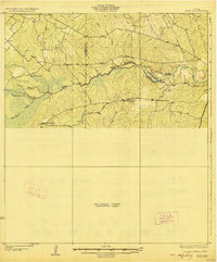 1927 Bart1927 Print · USGSThe Dimmit and La Salle County line comes alive in the mid-twenties, centered on the winding Nueces River. Genealogists and local historians can trace early ranching footprints at Cochina Ranch, Wernberger Ranch, and San Roque Ranch.3 unique versions available
 - 1929 Map of Cotulla
 1929 Cotulla1929 Print · USGSThe South Texas brush country comes alive in the late 1920s, showing a landscape of massive cattle ranches and early rail outposts. Genealogists can trace family holdings from the Carlow Settlement to Valley Wells, or locate military sites like Dentonio.
End of results
Showing maps 1-2 of 2
Top cities of La Salle County
Frequently asked questions
- What are the different types of historical maps available for La Salle County?
- What is the oldest map of La Salle County?
- Where can I purchase historical maps of La Salle County for my home or office?
- Where can I download high-res historical maps of La Salle County?
- Are there historical topographic maps available for La Salle County?
- Is there historical aerial imagery available for La Salle County?
- Where are historical maps of La Salle County sourced from?