1940s Maps of La Salle County, Texas
Explore 4 historic maps of La Salle County from the 1940s. These maps offer a rare glimpse into what life looked like during the 1940s — showing old roads, neighborhoods, homes, and landmarks that have changed or disappeared over time.
Whether you're researching your family's past, planning a metal detecting trip, or studying how La Salle County's landscape evolved across the 1940s, these high-resolution maps are a powerful tool for exploring the history of this region.
- Focus on a specific era: All maps on this page are from the 1940s, giving you a focused view of this time period.
- See what’s changed: Compare century-old streets, trails, and buildings to today's modern landscape using overlays and satellite layers.
- Research with precision: Use these maps for genealogy, historical research, land use analysis, or educational projects.
- View, download, or print: Maps are fully viewable online in high resolution, and can be downloaded or printed for your own records.
Start exploring La Salle County's history through authentic maps from the 1940s. This is your window into the past.
La Salle County, TX maps
(4)- 1940 Map of Cotulla
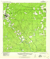 1940 Cotulla1940 Print · USGSLa Salle County ranching life is frozen in time at the start of the 1940s, centered on the rail junction at Cotulla. Genealogists and historians can trace family landmarks across the brush country, from the Buckholt School to the Albert Martin Ranch and Harriss Valley.
 - 1940 Map of Artesia Wells, 1959 Print
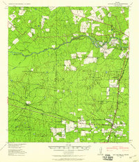 1940 Artesia Wells1959 Print · USGSLa Salle and Dimmit Counties are captured here just before the Second World War, showing a ranching landscape defined by the Nueces River. Researchers can trace family homesteads like R Armstrong and J Henderson or follow the path of the International-Great Northern Railroad through Artesia Wells.
 - 1942 Map of Fowlerton
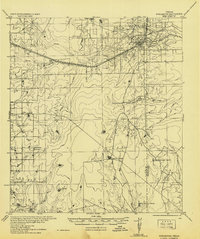 1942 Fowlerton1942 Print · USGSSouth Texas ranching and rail commerce converge in the early 1940s near the Frio River. Researchers can trace historic family holdings like Guadalupe Ranch or follow the path of the San Antonio Uvalde and Gulf State Highway No 72.
 - 1942 Map of Dilley, 1956 Print
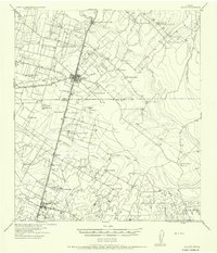 1942 Dilley1956 Print · USGSSouth Texas ranching and rail infrastructure are on full display during the early 1940s at the Frio and La Salle county line. Genealogists and historians can trace family properties like Nagy Witherspoon Ranch and Julia Harris Ranch along the International and Great Northern railroad.
End of results
Showing maps 1-4 of 4
Top cities of La Salle County
Frequently asked questions
- What are the different types of historical maps available for La Salle County?
- What is the oldest map of La Salle County?
- Where can I purchase historical maps of La Salle County for my home or office?
- Where can I download high-res historical maps of La Salle County?
- Are there historical topographic maps available for La Salle County?
- Is there historical aerial imagery available for La Salle County?
- Where are historical maps of La Salle County sourced from?