2000-2009 Maps of La Salle County, Texas
Explore 4 historic maps of La Salle County from 2000-2009. These maps offer a rare glimpse into what life looked like during the 2000s — showing old roads, neighborhoods, homes, and landmarks that have changed or disappeared over time.
Whether you're researching your family's past, planning a metal detecting trip, or studying how La Salle County's landscape evolved across the 2000s, these high-resolution maps are a powerful tool for exploring the history of this region.
- Focus on a specific era: All maps on this page are from the 2000s, giving you a focused view of this time period.
- See what’s changed: Compare century-old streets, trails, and buildings to today's modern landscape using overlays and satellite layers.
- Research with precision: Use these maps for genealogy, historical research, land use analysis, or educational projects.
- View, download, or print: Maps are fully viewable online in high resolution, and can be downloaded or printed for your own records.
Start exploring La Salle County's history through authentic maps from the 2000s. This is your window into the past.
La Salle County, TX maps
(4)- 2001 Map of Artesia
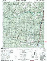 2001 Artesia2001 Print · USGSSouth Texas ranching country comes into focus at the start of the millennium, centered on the Artesia Wells corridor. Researchers can trace land ownership through prominent properties like Cochina Ranch and Richey Ranch, or locate remote landmarks like the Rancho Encantada and the winding Nueces River.
 - 2002 Map of Dilley
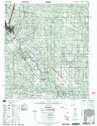
 2002 Dilley2002 Print · USGSThe South Texas Brush Country around the turn of the millennium shows a landscape defined by ranching and the rail corridor. Researchers can locate the Dilley Cemetery, follow the Union Pacific Railroad through Millett, or trace the banks of Cibolo Creek.
 - 2002 Map of Cotulla
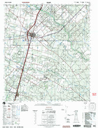
 2002 Cotulla2002 Print · USGSThe Brush Country of South Texas is captured at the opening of the millennium, centered on the regional hub of Cotulla and the Nueces River valley. Researchers can trace land use through features like the Black Ranch, the small settlement of Los Angeles, and the local Cemetery.
 - 2003 Map of Caiman Creek
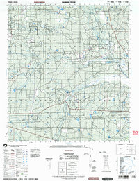 2003 Caiman Creek2003 Print · USGSSouth Texas ranch lands at the start of the 21st century are mapped here along the Nueces River and the La Salle and Webb county line. Researchers can locate the Fort Ewell Historical Monument and landmarks like Monte Cortado among the brush and creek beds.
End of results
Showing maps 1-4 of 4
Top cities of La Salle County
Frequently asked questions
- What are the different types of historical maps available for La Salle County?
- What is the oldest map of La Salle County?
- Where can I purchase historical maps of La Salle County for my home or office?
- Where can I download high-res historical maps of La Salle County?
- Are there historical topographic maps available for La Salle County?
- Is there historical aerial imagery available for La Salle County?
- Where are historical maps of La Salle County sourced from?