1960s Maps of La Salle County, Texas
Explore 10 historic maps of La Salle County from the 1960s. These maps offer a rare glimpse into what life looked like during the 1960s — showing old roads, neighborhoods, homes, and landmarks that have changed or disappeared over time.
Whether you're researching your family's past, planning a metal detecting trip, or studying how La Salle County's landscape evolved across the 1960s, these high-resolution maps are a powerful tool for exploring the history of this region.
- Focus on a specific era: All maps on this page are from the 1960s, giving you a focused view of this time period.
- See what’s changed: Compare century-old streets, trails, and buildings to today's modern landscape using overlays and satellite layers.
- Research with precision: Use these maps for genealogy, historical research, land use analysis, or educational projects.
- View, download, or print: Maps are fully viewable online in high resolution, and can be downloaded or printed for your own records.
Start exploring La Salle County's history through authentic maps from the 1960s. This is your window into the past.
La Salle County, TX maps
(10)- 1961 Map of Crystal City
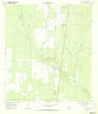
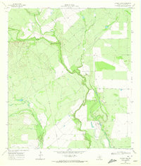
 1961 Crystal City1961 Print · USGSSouth Texas in the early sixties reveals a landscape of massive cattle ranches and emerging oil fields. Genealogists and historians can trace the Missouri Pacific rail lines through Crystal City, or locate water features like Espantosa Lake and Boynton Reservoir.
 - 1968 Map of Crystal City
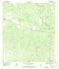
 1968 Crystal City1968 Print · USGSSouth Texas in the late sixties reveals a landscape shaped by ranching roots and the vital waters of the Nueces River. Researchers can trace the rail-driven growth of Crystal City or locate landmarks like Pilot Knob and Espantosa Lake.
 - 1968 Map of Zella, 1972 Print
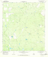
 1968 Zella1972 Print · USGSIn the ranchlands of South Texas during the late sixties, this survey tracks the boundary of La Salle and McMullen counties. Researchers can trace the winding Esperanza Creek and find sites like Zella, the Esperanza Ranch, and numerous Gravel Pits.2 unique versions available
 - 1969 Map of Dull, 1971 Print
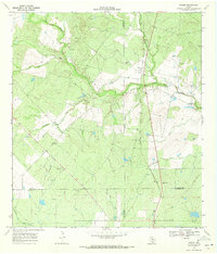
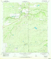
 1969 Dull1971 Print · USGSLa Salle County ranching and early oil exploration are documented here during the late sixties. Trace the defunct Old Railroad Grade between Los Angeles and Dull, or locate family-named water sources like Quintana Tank and McGraw Lake.
 - 1969 Map of Hindes, 1971 Print
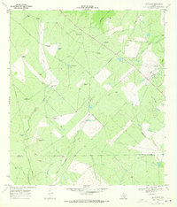
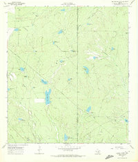
 1969 Hindes1971 Print · USGSSouth Texas ranching country at the meeting of four counties is captured here in the late sixties. Trace the remnants of the Old Railroad Grade near Hindes or locate specific Oil Wells and the rural settlement of Orelia.
 - 1969 Map of Las Flores, 1971 Print
 1969 Las Flores1971 Print · USGSThe ranchlands along the Frio and La Salle county line come to life in this late-sixties survey. Researchers can trace historic water sources and family landmarks like the San Jose Ranch, Caballo Blanco Windmill, and Las Flores.
 - 1969 Map of Cayman Lake, 1972 Print
 1969 Cayman Lake1972 Print · USGSThe South Texas brush country along the Frio River is captured here in the late sixties, showing a landscape of ranching and riverine sloughs. Genealogists and historians can trace family-held land like Sharp Ranch, the settlement of Angeles, and the waters of Cayman Lake.
 - 1969 Map of The White Kitchen, 1972 Print
 1969 The White Kitchen1972 Print · USGSLa Salle County ranchlands and oil patches are captured here in the late sixties, showing a landscape shaped by energy and cattle. Trace the locations of The White Kitchen, Quintana Camp, and numerous named water sources like 14 Section Tank and Maguey Tank.2 unique versions available
 - 1969 Map of Fowlerton, 1972 Print
 1969 Fowlerton1972 Print · USGSSouth Texas ranching and river life are captured here in the late sixties along the Frio River. Genealogists and historians can trace family ties at Galinda Ranch or locate the Fowlerton Cems and landmarks like Koon Hill.
 - 1969 Map of Briscoe Ranch, 1972 Print
 1969 Briscoe Ranch1972 Print · USGSSouth Texas ranching and oil operations are mapped in detail during the late sixties at the La Salle and McMullen county line. Researchers can trace historic ranch infrastructure through Briscoe Ranch and a vast network of stock tanks like Big Alamo Tank and Tanque Porfido.
End of results
Showing maps 1-10 of 10
Top cities of La Salle County
Frequently asked questions
- What are the different types of historical maps available for La Salle County?
- What is the oldest map of La Salle County?
- Where can I purchase historical maps of La Salle County for my home or office?
- Where can I download high-res historical maps of La Salle County?
- Are there historical topographic maps available for La Salle County?
- Is there historical aerial imagery available for La Salle County?
- Where are historical maps of La Salle County sourced from?