1980s Maps of Lee County, Texas
Explore 10 historic maps of Lee County from the 1980s. These maps offer a rare glimpse into what life looked like during the 1980s — showing old roads, neighborhoods, homes, and landmarks that have changed or disappeared over time.
Whether you're researching your family's past, planning a metal detecting trip, or studying how Lee County's landscape evolved across the 1980s, these high-resolution maps are a powerful tool for exploring the history of this region.
- Focus on a specific era: All maps on this page are from the 1980s, giving you a focused view of this time period.
- See what’s changed: Compare century-old streets, trails, and buildings to today's modern landscape using overlays and satellite layers.
- Research with precision: Use these maps for genealogy, historical research, land use analysis, or educational projects.
- View, download, or print: Maps are fully viewable online in high resolution, and can be downloaded or printed for your own records.
Start exploring Lee County's history through authentic maps from the 1980s. This is your window into the past.
Lee County, TX maps
(10)- 1982 Map of Elgin East
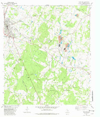 1982 Elgin East1982 Print · USGSBastrop County's industrial and military character is on display in the early eighties as the rail lines of the Southern Pacific serve the local clay industry. Genealogists can locate several family burial grounds like Old George Cem and Smith Cem alongside the expansive Camp Swift Military Reservation.2 unique versions available
 - 1982 Map of Structure
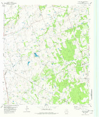 1982 Structure1982 Print · USGSThe rural borderlands of Williamson and Bastrop counties are captured in the early eighties as a network of creeks and rail lines. Genealogists can locate family burial sites at Type Cem and Mager Cem, or trace the old Missouri Kansas Texas railroad near Structure.
 - 1982 Map of Fedor
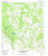
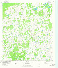 1982 Fedor1982 Print · USGSLee County rural life is captured here in the early eighties, showing a landscape defined by the winding West Yegua Creek. Genealogists can trace family heritage at Wolf Cem, Melcher Cem, and churches like Trinity Ch or Mt Nebo Ch.
 - 1982 Map of Beaukiss
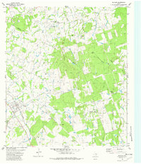
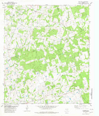 1982 Beaukiss1982 Print · USGSThe rural borderlands where Williamson, Milam, and Lee counties meet are detailed in this early 1980s record. Researchers can trace family ties through Guentzel Cem, the Lawrence Chapel church, and the small settlements of Beaukiss and Blue.
 - 1982 Map of Winchester
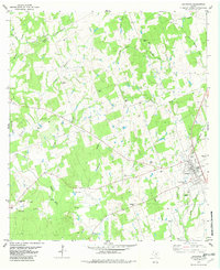
 1982 Winchester1982 Print · USGSThe community of Winchester in the early 1980s sits at the crossroads of the Southern Pacific railroad and the Colorado River. Genealogists can trace family landmarks like St Marys Cem, Shiloh Cemetery, and the Center Union Community Center.
 - 1982 Map of Paige
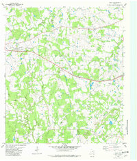 1982 Paige1982 Print · USGSCentral Texas rural life in the early eighties centers on the rail corridor and the county line between Bastrop and Lee. Genealogists can trace family roots through the Friendship Cem, St Johns Ch, and the settlement at Manheim.
 - 1982 Map of Lexington
 1982 Lexington1982 Print · USGSLexington and the surrounding cattle-and-creek country of Lee County are shown here in the early eighties. Genealogists and historians can trace family locations through numerous rural burial sites like Phears Cem and Mesquite Cem, or locate the Old Railroad Grade.
 - 1982 Map of McDade
 1982 McDade1982 Print · USGSThe Bastrop and Lee County borderlands come into focus in the early eighties, showing the rail-centered community of Mc Dade and the surrounding timbered hills. Genealogists can trace deep local roots through a high density of burial sites including Sanders Cem, Henderson Cem, and Shiloh Cem.
 - 1985 Map of Austin
 1985 Austin1985 Print · USGSCentral Texas in the mid-eighties reveals a region in transition, balancing rapid urban growth in Austin with deep-rooted rural landscapes. Genealogists and historians can trace family locations near St Johns Ch, the Science Hall schoolhouse, and long-standing communities like Webberville and Manchaca.3 unique versions available
 - 1985 Map of Taylor, 1986 Print
 1985 Taylor1986 Print · USGSWilliamson and Bell counties in the mid-eighties reveal a landscape where the cattle and cotton economy met burgeoning rail infrastructure. Genealogists and historians can trace the paths of the Missouri Pacific railroad through unique hamlets like Ding Dong, Frame Switch, and Beyersville.2 unique versions available
End of results
Showing maps 1-10 of 10
Top cities of Lee County
Frequently asked questions
- What are the different types of historical maps available for Lee County?
- What is the oldest map of Lee County?
- Where can I purchase historical maps of Lee County for my home or office?
- Where can I download high-res historical maps of Lee County?
- Are there historical topographic maps available for Lee County?
- Is there historical aerial imagery available for Lee County?
- Where are historical maps of Lee County sourced from?