1960s Maps of Lee County, Texas
Explore 6 historic maps of Lee County from the 1960s. These maps offer a rare glimpse into what life looked like during the 1960s — showing old roads, neighborhoods, homes, and landmarks that have changed or disappeared over time.
Whether you're researching your family's past, planning a metal detecting trip, or studying how Lee County's landscape evolved across the 1960s, these high-resolution maps are a powerful tool for exploring the history of this region.
- Focus on a specific era: All maps on this page are from the 1960s, giving you a focused view of this time period.
- See what’s changed: Compare century-old streets, trails, and buildings to today's modern landscape using overlays and satellite layers.
- Research with precision: Use these maps for genealogy, historical research, land use analysis, or educational projects.
- View, download, or print: Maps are fully viewable online in high resolution, and can be downloaded or printed for your own records.
Start exploring Lee County's history through authentic maps from the 1960s. This is your window into the past.
Lee County, TX maps
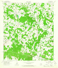
(6)- 1960 Map of Tanglewood, 1962 Print
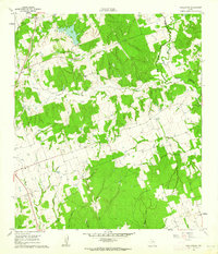 1960 Tanglewood1962 Print · USGSLee County as it appeared in the early 1960s was a landscape defined by the Southern Pacific rail line and rural church communities. Genealogists can locate family burial sites at Mt Zion Cem or German Cem and trace the paths of East Yegua Creek and its many branches.3 unique versions available
 - 1960 Map of Deanville, 1963 Print
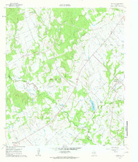 1960 Deanville1963 Print · USGSBurleson and Lee counties in the early sixties reveal a landscape of rural schoolhouses and family cemeteries along the railroad. Genealogists can locate Sulphur Spring School, San Antonio Prairie Cemetery, and the original site of Old Dime Box.3 unique versions available
 - 1961 Map of Lincoln, 1962 Print
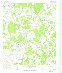 1961 Lincoln1962 Print · USGSLee County's rural landscape is captured here in the early sixties, showing the transition from old rail routes to modern ranching. Researchers can trace family-named sites like Molly Smith Lake and Gloyds Cem, or locate historic hubs like Lincoln and Loebau.3 unique versions available
 - 1962 Map of Hicks, 1964 Print
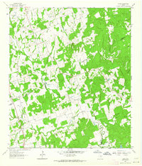 1962 Hicks1964 Print · USGSThe tri-county junction of Milam, Lee, and Burleson counties is captured in the early sixties as a landscape of rural industry and community. Researchers can trace family history at Harmony Cem or locate the old Railroad Grade and Hicks Mine.2 unique versions available
 - 1962 Map of Warda, 1965 Print
 1962 Warda1965 Print · USGSLee and Fayette Counties are shown in the early sixties as rural Texas life followed the rail lines and creek beds. Genealogists and local historians can trace family locations near Northrup, St Paul Ch, and the school at Warda.2 unique versions available
 - 1963 Map of Alcoa Lake, 1966 Print
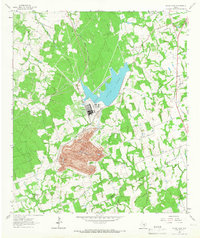 1963 Alcoa Lake1966 Print · USGSThe Milam and Lee County border undergoes an industrial shift in the early sixties. Researchers can trace the massive Strip Mine operations at Sandow or locate rural family sites like Richards Cem and Holliman Cem.2 unique versions available
End of results
Showing maps 1-6 of 6
Top cities of Lee County
Frequently asked questions
- What are the different types of historical maps available for Lee County?
- What is the oldest map of Lee County?
- Where can I purchase historical maps of Lee County for my home or office?
- Where can I download high-res historical maps of Lee County?
- Are there historical topographic maps available for Lee County?
- Is there historical aerial imagery available for Lee County?
- Where are historical maps of Lee County sourced from?