1800s (19th Century) Maps of Mason County, Texas
Explore 6 historic maps of Mason County from the 1800s (19th Century). These maps offer a rare glimpse into what life looked like during the 1800s — showing old roads, neighborhoods, homes, and landmarks that have changed or disappeared over time.
Whether you're researching your family's past, planning a metal detecting trip, or studying how Mason County's landscape evolved across the 1800s, these high-resolution maps are a powerful tool for exploring the history of this region.
- Focus on a specific era: All maps on this page are from the 1800s, giving you a focused view of this time period.
- See what’s changed: Compare century-old streets, trails, and buildings to today's modern landscape using overlays and satellite layers.
- Research with precision: Use these maps for genealogy, historical research, land use analysis, or educational projects.
- View, download, or print: Maps are fully viewable online in high resolution, and can be downloaded or printed for your own records.
Start exploring Mason County's history through authentic maps from the 1800s. This is your window into the past.
Mason County, TX maps
(6)- 1887 Map of Llano
 1887 Llano1887 Print · USGSThe Texas Hill Country emerges as a frontier of granite peaks and river valleys in the mid-1880s. Researchers can locate early settlements like Castell and Baby Head, or trace the rugged topography of Enchanted Rock and Pack Saddle Mountain.
 - 1887 Map of Mason
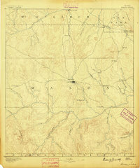 1887 Mason1887 Print · USGSThe Texas Hill Country comes into focus during the late frontier era, centering on the vital cattle and trade crossroads of Mason. Researchers can trace early German-Texan settlements and rural post offices including Loyal Valley, Hoersterville, and Fredonia.
 - 1894 Map of Mason
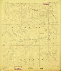
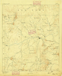
 1894 Mason1894 Print · USGSTexas Hill Country ranching and frontier life are captured here in the 1890s, centered on the growing county seat. Genealogists can trace family-named settlements like Bodeville and Hoersterville or remote outposts like Camp San Saba.4 unique versions available
 - 1894 Map of Fredericksburg
 1894 Fredericksburg1894 Print · USGSTexas Hill Country life in the late 1800s is centered on Fredericksburg and the banks of the Pedernales River. Genealogists and historians can trace early settlements and post offices like Martinsburgh, Westbrook, and the curiously named Blowout.4 unique versions available
 - 1894 Map of Kerrville
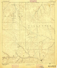 1894 Kerrville1894 Print · USGSThe Texas Hill Country in the late nineteenth century was a land of river-valley outposts and high divides. Genealogists and researchers can trace the early footprints of Kerrville, Harper, and Ingram, or locate rural landmarks like Johnson Resort and Steamboat Mountain.4 unique versions available
 - 1894 Map of Llano
 1894 Llano1894 Print · USGSThe Llano Uplift of Central Texas is captured here in the late nineteenth century as a landscape of remote ranching outposts and granite peaks. Genealogists and historians can trace the early layouts of Llano, Castell, and the community of Baby Head.
End of results
Showing maps 1-6 of 6
Top cities of Mason County
Frequently asked questions
- What are the different types of historical maps available for Mason County?
- What is the oldest map of Mason County?
- Where can I purchase historical maps of Mason County for my home or office?
- Where can I download high-res historical maps of Mason County?
- Are there historical topographic maps available for Mason County?
- Is there historical aerial imagery available for Mason County?
- Where are historical maps of Mason County sourced from?