1950s Maps of Maverick County, Texas
Explore 4 historic maps of Maverick County from the 1950s. These maps offer a rare glimpse into what life looked like during the 1950s — showing old roads, neighborhoods, homes, and landmarks that have changed or disappeared over time.
Whether you're researching your family's past, planning a metal detecting trip, or studying how Maverick County's landscape evolved across the 1950s, these high-resolution maps are a powerful tool for exploring the history of this region.
- Focus on a specific era: All maps on this page are from the 1950s, giving you a focused view of this time period.
- See what’s changed: Compare century-old streets, trails, and buildings to today's modern landscape using overlays and satellite layers.
- Research with precision: Use these maps for genealogy, historical research, land use analysis, or educational projects.
- View, download, or print: Maps are fully viewable online in high resolution, and can be downloaded or printed for your own records.
Start exploring Maverick County's history through authentic maps from the 1950s. This is your window into the past.
Maverick County, TX maps
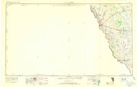
(4)- 1957 Map of Indio Creek
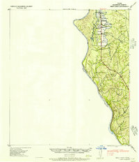 1957 Indio Creek1957 Print · USGSTexas ranching culture meets the international border in the mid-1950s along the winding river. Genealogists can trace family-named outposts and landholdings such as the Indio Cattle Co, D H Havin, and A Barnes near the banks of Indio Creek.2 unique versions available
 - 1957 Map of Botella Creek
 1957 Botella Creek1957 Print · USGSSouth Texas ranching country at the mid-century reveals a landscape dependent on isolated water tanks and family-run spreads. Genealogists can trace property names like Glass Ranch, Red Ranch, and landmarks such as Mc Furland Tank.
 - 1958 Map of Eagle Pass, 1969 Print
 1958 Eagle Pass1969 Print · USGSThe borderlands of South Texas come alive in this mid-century look at the ranching and rail corridor along the Rio Grande. Genealogists and historians can trace legacy holdings like San Pedro Ranch, find the Maverick Canal network, and locate rail sidings at Darling.2 unique versions available
 - 1958 Map of Del Rio, 1970 Print
 1958 Del Rio1970 Print · USGSThe Texas-Mexico borderlands come alive in the late fifties, showing the confluence of the Rio Grande and the emerging Amistad Reservoir. Trace the lineage of the Southern Pacific rail line through stops at Pumpville, Shumla, and the mining vicinity of Blewett.2 unique versions available
End of results
Showing maps 1-4 of 4
Top cities of Maverick County
- Eagle Pass historical maps
- Chula Vista historical maps
- Rosita historical maps
- Las Quintas Fronterizas historical maps
- El Indio historical maps
Frequently asked questions
- What are the different types of historical maps available for Maverick County?
- What is the oldest map of Maverick County?
- Where can I purchase historical maps of Maverick County for my home or office?
- Where can I download high-res historical maps of Maverick County?
- Are there historical topographic maps available for Maverick County?
- Is there historical aerial imagery available for Maverick County?
- Where are historical maps of Maverick County sourced from?