1980s Maps of Maverick County, Texas
Explore 19 historic maps of Maverick County from the 1980s. These maps offer a rare glimpse into what life looked like during the 1980s — showing old roads, neighborhoods, homes, and landmarks that have changed or disappeared over time.
Whether you're researching your family's past, planning a metal detecting trip, or studying how Maverick County's landscape evolved across the 1980s, these high-resolution maps are a powerful tool for exploring the history of this region.
- Focus on a specific era: All maps on this page are from the 1980s, giving you a focused view of this time period.
- See what’s changed: Compare century-old streets, trails, and buildings to today's modern landscape using overlays and satellite layers.
- Research with precision: Use these maps for genealogy, historical research, land use analysis, or educational projects.
- View, download, or print: Maps are fully viewable online in high resolution, and can be downloaded or printed for your own records.
Start exploring Maverick County's history through authentic maps from the 1980s. This is your window into the past.
Maverick County, TX maps
(19)- 1982 Map of Tovar Creek East
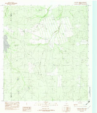
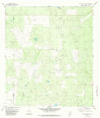
 1982 Tovar Creek East1982 Print · USGSMaverick County ranch land and drainage basins are captured here in the early eighties. Researchers can trace the ranching economy through water features like Hiller Tank and San Ambrosia Creek, or locate the isolated Landing Strips.
 - 1982 Map of Indio Tank
 1982 Indio Tank1982 Print · USGSMaverick County ranch lands are detailed in the early eighties, showcasing the vital network of water sources in the South Texas brush. Trace the placement of cattle tanks and remote infrastructure like Indio Tank, San Ambrosia Creek, and a small Landing Strip.
 - 1982 Map of Eagle Pass NE
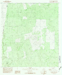
 1982 Eagle Pass NE1982 Print · USGSMaverick County ranch lands are documented here in the early eighties, showcasing a landscape of intermittent creeks and isolated outposts. Researchers can locate the Farias Ranch and trace the path of the Maverick County Canal through Mule Creek country.
 - 1982 Map of Farias Ranch
 1982 Farias Ranch1982 Print · USGSMaverick County ranching country is captured here in the early eighties, showing the isolated homesteads and desert waterways of South Texas. Researchers can locate Farias Ranch and trace the drainage of Comanche Creek and San Ambrosia Creek.
 - 1982 Map of Cayetano Creek
 1982 Cayetano Creek1982 Print · USGSThe brush country of Dimmit and Maverick counties comes into focus in the early eighties, showing a landscape shaped by intermittent water and ranching. Trace the paths of Comanche Creek and Pendencia Creek alongside an isolated Landing Strip.
 - 1982 Map of San Pedro Creek
 1982 San Pedro Creek1982 Print · USGSThe South Texas brush country along the Maverick and Dimmit county line is captured here in the early eighties. Researchers can trace the drainage of San Pedro Creek and locate local landmarks like the Gravel Pit and Botella Creek.
 - 1983 Map of Tovar Creek West
 1983 Tovar Creek West1983 Print · USGSThe Texas-Mexico borderlands along the Rio Grande come into focus in the early 1980s, documenting the rural landscape of Maverick County. Genealogists and historians can trace riverside settlements like Guerrero and Santa Elena alongside local ranching landmarks like Mansfield Tank.
 - 1983 Map of Salt Well
 1983 Salt Well1983 Print · USGSThe international boundary along the Rio Grande Rio Bravo defines this borderland in the early eighties. Genealogists and local researchers can trace old ranchos and settlements like Salt Well, El Almagre, and La Gallareta across the Texas and Coahuila landscape.
 - 1983 Map of Eagle Pass East
 1983 Eagle Pass East1983 Print · USGSThe Texas-Mexico borderlands come into focus in the early 1980s as the river winds south of Maverick County. Researchers can trace the layout of Seco Mines, locate the Eagle Pass Municipal Airport, and find early irrigation works along the Canal.
 - 1983 Map of Eagle Pass West
 1983 Eagle Pass West1983 Print · USGSThe international border at the Rio Grande defines this 1980s landscape, where the Texas city of Eagle Pass meets the streets of Piedras Negras. Local researchers can trace family names and settlements like Fuentes, San Joaquin, and Las Esperanzas.2 unique versions available
 - 1983 Map of El Indio
 1983 El Indio1983 Print · USGSThe Texas-Mexico border comes into focus in the early 1980s as the river defines the international line near El Indio. Researchers can trace the path of the Maverick Canal and locate rural landmarks like Beaver Tank and Cuevas Creek.
 - 1983 Map of Indio Creek
 1983 Indio Creek1983 Print · USGSMaverick County sits along the international border in the early 1980s, showcasing the remote ranching landscape of the Rio Grande valley. Researchers can trace the river's edge past San Vicente and Castillon, or locate scattered landmarks like Indio Lake and Coyote Tank.
 - 1983 Map of San Ambrosia Creek 3 NE
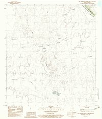 1983 San Ambrosia Creek 3 NE1983 Print · USGSThe international boundary along the Rio Grande comes into focus in the early 1980s, revealing the remote ranching landscape of Maverick County. Researchers can trace old trails and outposts like Buenavista, Las Viboras, and El Gato across this cross-border terrain.2 unique versions available
 - 1983 Map of Eagle Pass SW
 1983 Eagle Pass SW1983 Print · USGSThe international border along the Rio Grande was a network of small settlements and customs outposts in the early eighties. Researchers can locate El Saucito (Aduana), the deserted site at Santo Domingo (Abandonado), and the course of the Maverick County Canal.
 - 1984 Map of Palo Blanco Tank
 1984 Palo Blanco Tank1984 Print · USGSDimmit and Maverick counties come into focus during the mid-eighties as a region defined by ranching and energy production. Researchers can locate family-named holdings like Yet Ranch or trace the vital water sources at English Tank and Palo Blanco Tank.
 - 1984 Map of Chupadera Creek
 1984 Chupadera Creek1984 Print · USGSThe South Texas borderlands near the Rio Grande appear here in the mid-1980s, showing a landscape of sprawling ranching operations. Researchers can trace the layout of Faith Ranch, locate remote landmarks like Cathedral Rock, and find water sources such as Chupadera Spring.
 - 1985 Map of Eagle Pass
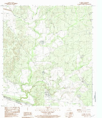
 1985 Eagle Pass1985 Print · USGSThe Texas-Mexico borderlands come into focus in the mid-1980s as Eagle Pass grows along the Rio Grande. Genealogists and historians can trace the rail corridor of the Southern Pacific and locate rural communities like Normandy and El Indio.
 - 1985 Map of San Ambrosia Creek
 1985 San Ambrosia Creek1985 Print · USGSMaverick and Dimmit counties are seen here in the mid-1980s, where the international border meets the ranching country of South Texas. Local historians can trace water management sites and remote landmarks like Chupadera Spring, Cathedral Rock, and the Salt Well.
 - 1986 Map of Del Rio
 1986 Del Rio1986 Print · USGSThe West Texas borderlands come alive in the mid-eighties as Del Rio expands and Laughlin AFB anchors the local economy. Researchers can trace the rail corridors through Spofford and Cline or locate family sites near Alamo Village.2 unique versions available
End of results
Showing maps 1-19 of 19
Top cities of Maverick County
- Eagle Pass historical maps
- Chula Vista historical maps
- Rosita historical maps
- Las Quintas Fronterizas historical maps
- El Indio historical maps
Frequently asked questions
- What are the different types of historical maps available for Maverick County?
- What is the oldest map of Maverick County?
- Where can I purchase historical maps of Maverick County for my home or office?
- Where can I download high-res historical maps of Maverick County?
- Are there historical topographic maps available for Maverick County?
- Is there historical aerial imagery available for Maverick County?
- Where are historical maps of Maverick County sourced from?