Old Maps of Maverick County, Texas for Academic Research
Study the evolution of Maverick County with 232 high-resolution historic maps. Whether you're teaching, researching, or modeling changes in land use, these maps provide essential visual documentation of urban, environmental, and geographic change.
- Analyze long-term change: Track patterns in development, transportation, and natural features.
- Ideal for environmental or urban studies: Support academic projects with primary historical map data.
- Use in the classroom or lab: Educators and researchers rely on these maps to bring historical context to life.
These maps are a powerful tool for teaching, research, and visualizing how Maverick County has changed over the decades.
Maverick County, TX maps
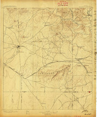
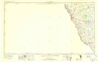
(232)- 1896 Map of Brackett
 1896 Brackett1896 Print · USGSSouthwest Texas ranching and military life come into focus in the 1890s, centered on the strategic presence of the frontier army. Genealogists can trace family holdings like Weymiller Ranch or find early communities such as the Seminole Settlement and Spofford.
 - 1897 Map of Brackett
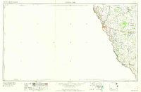
 1897 Brackett1897 Print · USGSThe frontier of Kinney and Uvalde counties is captured here in the late nineteenth century, centered on the military and ranching hub of Brackett. Researchers can trace the Southern Pacific R. R. through Cline or locate the historic Seminole Settlement and Fort Clark.3 unique versions available
 - 1940 Map of Cometa, 1958 Print
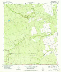
 1940 Cometa1958 Print · USGSSouthwest Texas ranching country in the early nineteen-forties shows a landscape of large family holdings and seasonal creek beds. Genealogists can trace specific homesteads such as the Sullivan Ranch, F C Anglin Ranch, and the small settlement at Cometa.2 unique versions available
 - 1940 Map of Eagle Pass, 1959 Print
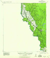
 1940 Eagle Pass1959 Print · USGSMaverick County sits along the winding bend of the Rio Grande during the early days of the Second World War. Researchers can trace numerous family-named landmarks and agricultural holdings like Milton Frank Farms, La Rosita Ranch, and the Sullivan Ranch.
 - 1940 Map of Chupadera, 1959 Print
 1940 Chupadera1959 Print · USGSThe Texas-Mexico borderlands along the Rio Grande are captured here just before the war, showing the remote ranching country of Webb Co. Researchers can locate isolated water sources and early landmarks like Chupadera Ranch, Sullivan Spring, and Cathedral Rock.2 unique versions available
 - 1940 Map of Paloma, 1959 Print
 1940 Paloma1959 Print · USGSMaverick County ranch lands and early energy infrastructure are detailed here at the dawn of the 1940s. Genealogists and historians can trace family operations like Burr Ranch and Sullivan Ranch, or locate the specific footprint of the Chittim Gas Field.
 - 1940 Map of Quemado, 1959 Print
 1940 Quemado1959 Print · USGSMaverick County sits along the Rio Grande during the early years of the war, showcasing a landscape of riverside irrigation and military expansion. Researchers can find family-named sites like Lehmann Ranch, the local Hydro Elec Plant, and the layout of the Eagle Pass Army Airfield.
 - 1940 Map of Chacon Creek, 1959 Print
 1940 Chacon Creek1959 Print · USGSRanching operations and early energy pipelines define the Maverick and Zavala County line at the start of the 1940s. Genealogists and historians can locate family-named homesteads such as Plumly Ranch and Van Cleve Ranch or trace water sources like Chilipin Lake.
 - 1941 Map of Botella Creek
 1941 Botella Creek1941 Print · USGSThe Maverick and Dimmit county lines meet in this brush-country landscape during the early years of the Second World War. Researchers can trace the heritage of remote family outposts like Tovar Ranch and Red Ranch or locate vital water sources such as Indio Tank and Lopez Tank.
 - 1941 Map of Tequesquite Creek, 1977 Print
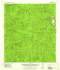
 1941 Tequesquite Creek1977 Print · USGSThe South Texas borderlands come alive in this early wartime survey of Kinney and Maverick Counties. Historians and genealogists can trace the footprint of the Southern Pacific railroad and family lands like Herbst Ranch or the Eagle Pass Auxiliary Landing Field No 2.
 - 1944 Map of Tequesquite Creek
 1944 Tequesquite Creek1944 Print · USGSKinney and Maverick Counties are shown during the mid-1940s, a period defined by sprawling border ranchlands and wartime aviation. Local researchers can trace family holdings like Sockwell Ranch or locate aviation history at Eagle Pass Auxiliary Landing Field No 2.
 - 1944 Map of Spofford
 1944 Spofford1944 Print · USGSThe rail junctions of southwest Texas come alive in the 1940s as the Southern Pacific meets the Texas and New Orleans at Spofford. Researchers can trace the sprawling ranching culture of the era through sites like Anacacho Headquarters Ranch, Beidler Ranch, and the siding at Nora.
 - 1949 Map of Cline
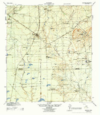
 1949 Cline1949 Print · USGSSouthwest Texas ranching and asphalt mining are captured here in the late 1930s and 40s. Genealogists and historians can locate family landmarks like Finley Ranch and trace the specialized Asphalt Belt Line railroad serving Blewett.2 unique versions available
 - 1957 Map of Indio Creek
 1957 Indio Creek1957 Print · USGSTexas ranching culture meets the international border in the mid-1950s along the winding river. Genealogists can trace family-named outposts and landholdings such as the Indio Cattle Co, D H Havin, and A Barnes near the banks of Indio Creek.2 unique versions available
 - 1957 Map of Botella Creek
 1957 Botella Creek1957 Print · USGSSouth Texas ranching country at the mid-century reveals a landscape dependent on isolated water tanks and family-run spreads. Genealogists can trace property names like Glass Ranch, Red Ranch, and landmarks such as Mc Furland Tank.
 - 1958 Map of Eagle Pass, 1969 Print
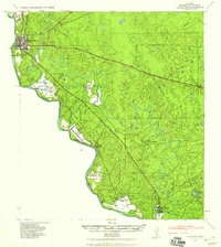
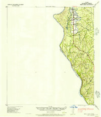
 1958 Eagle Pass1969 Print · USGSThe borderlands of South Texas come alive in this mid-century look at the ranching and rail corridor along the Rio Grande. Genealogists and historians can trace legacy holdings like San Pedro Ranch, find the Maverick Canal network, and locate rail sidings at Darling.2 unique versions available
 - 1958 Map of Del Rio, 1970 Print
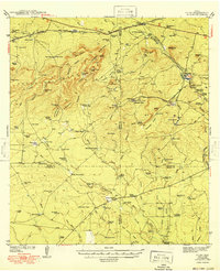
 1958 Del Rio1970 Print · USGSThe Texas-Mexico borderlands come alive in the late fifties, showing the confluence of the Rio Grande and the emerging Amistad Reservoir. Trace the lineage of the Southern Pacific rail line through stops at Pumpville, Shumla, and the mining vicinity of Blewett.2 unique versions available
 - 1964 Map of Del Rio
 1964 Del Rio1964 Print · USGSAlong the Mexican border during the mid-sixties, this area centered on the confluence of the Rio Grande and Devils River. Researchers can trace the Southern Pacific line through isolated stops like Pumpville or locate military and industrial sites such as Laughlin Air Force Base and the mines at Blewett.
 - 1965 Map of Eagle Pass
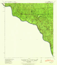
 1965 Eagle Pass1965 Print · USGSThe Texas-Mexico borderlands come into focus in the mid-1960s, centered on the river life and ranching culture of Maverick County. Researchers can trace the legacy of major landholdings like Burr Ranch and Loma Linda Ranch alongside landmarks like the Hydroelectric Plant.
 - 1974 Map of Cometa, 1977 Print
 1974 Cometa1977 Print · USGSThe South Texas Brush Country in the 1970s is captured here as the ranching and oil economies of Zavala and Dimmit counties intersect. Family historians can locate specific sites like Vivian Cem or the settlement of Cometa near the winding Comanche Creek.
 - 1974 Map of Goofy Lake, 1977 Print
 1974 Goofy Lake1977 Print · USGSMaverick and Kinney County ranchlands are documented here in the 1970s, showcasing a landscape defined by livestock tanks and seasonal creeks. Trace the isolated Holingreen Ranch or follow the paths of Muela Creek and Palo Blanco Creek.
 - 1974 Map of Olmos Creek, 1977 Print
 1974 Olmos Creek1977 Print · USGSThe brush country of South Texas in the mid-1970s is shown at the meeting point of four counties. Researchers can trace the essential water-security network of the era, from ranching landmarks like Government Tank and Muela Well to Kennedy Flats.
 - 1974 Map of Indian Tank, 1977 Print
 1974 Indian Tank1977 Print · USGSMaverick County ranching and energy production intersect in the 1970s across this Texas landscape. Researchers can trace the infrastructure of the Chittim Gas Field and locate historic water catchments like Rincon de Flores Tank and Indian Tank.
 - 1974 Map of Deadmans Hill, 1977 Print
 1974 Deadmans Hill1977 Print · USGSMaverick County in the mid-1970s was a landscape defined by ranching, rail, and the industrial infrastructure of Seco Mines. Researchers can trace the path of the Southern Pacific and an Old Railroad Grade past landmarks like Deadmans Hill.
 - 1974 Map of Trosado Tank, 1977 Print
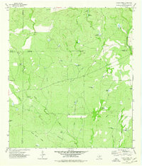
 1974 Trosado Tank1977 Print · USGSMaverick County ranch lands in the mid-1970s reveal a landscape optimized for water management and livestock. Researchers can trace historic water sources and property markers like Gallina Windmill, Trosado Tank, and the course of Salado Creek.
Showing maps 1-25 of 232
Top cities of Maverick County
- Eagle Pass historical maps
- Chula Vista historical maps
- Rosita historical maps
- Las Quintas Fronterizas historical maps
- El Indio historical maps
Frequently asked questions
- What are the different types of historical maps available for Maverick County?
- What is the oldest map of Maverick County?
- Where can I purchase historical maps of Maverick County for my home or office?
- Where can I download high-res historical maps of Maverick County?
- Are there historical topographic maps available for Maverick County?
- Is there historical aerial imagery available for Maverick County?
- Where are historical maps of Maverick County sourced from?