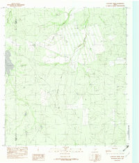
1982 Map of Cayetano Creek
USGS Topo · Published 1982About this map
Pendencia Creek and Cayetano Creek meander through this brush-country terrain on the early 1980s Texas frontier, where the landscape is defined by intermittent drainages and ranching infrastructure. The map documents the rural borderlands along the Maverick and Dimmit county line, a region characterized by its sparsely populated ranch tracts and isolated facilities like the Landing Strip in the northeast. This provisional survey captures the area's essential hydrology, anchored by the westward flow of Comanche Creek. The network of unimproved roads and trails depicted suggests a landscape where movement was dictated by the seasonal behavior of these creek beds, providing a detailed record of land use and property boundaries in South Texas before modern development shifted the rural character of the basin.
Find a feature on this map
5 named features on this map. Tap any name to fly to it.
Don’t see what you’re looking for? This feature index may not catch every label — zoom into the map to look around manually.
Map Details
Editions of this 1982 Cayetano Creek Map
This is the sole edition of this map. No revisions or reprints were ever made.
Other maps of this area

1929 · Cotulla
USGS Topo · 1:125,000

1939 · Carrizo Springs
USGS Topo · 1:62,500

1940 · Asherton
USGS Topo · 1:62,500

1940 · Cometa
USGS Topo · 1:62,500

1941 · Botella Creek
USGS Topo · 1:62,500

1953 · Crystal City
USGS Topo · 1:250,000

1955 · Crystal City
USGS Topo · 1:250,000

1957 · Botella Creek
USGS Topo · 1:62,500

1958 · Eagle Pass
USGS Topo · 1:250,000

1961 · Crystal City
USGS Topo · 1:250,000